IMAGES TAKEN NEAR TO
Manorowen, FISHGUARD, SA65 9PX
Introduction
This page details the photographs taken nearby to SA65 9PX by members of the Geograph project.
The Geograph project started in 2005 with the aim of publishing, organising and preserving representative images for every square kilometre of Great Britain, Ireland and the Isle of Man.

There are currently over 7.5m images from over14,400 individuals and you can help contribute to the project by visiting https://www.geograph.org.uk
Image Map (Loading...)


Getting Data...Please wait
Leaflet Map data © OpenStreetMap
Images are licensed for reuse under creativecommons.org/licenses/by-sa/2.0
Notes
- Clicking on the map will re-center to the selected point.
- The higher the marker number, the further away the image location is from the centre of the postcode.
Image Listing (16 Images Found)
Images are licensed for reuse under creativecommons.org/licenses/by-sa/2.0
Image
Details
Distance
1
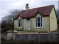
Little tin house
Small houses and other buildings made of corrugated metal sheets are quite a feature of the West Wales scene. This one, although evidently so neglected, seems to be in use. It is part of a cluster of cottages just off the road on the southern edge of Goodwick.
Image: © Natasha Ceridwen de Chroustchoff
Taken: 8 Feb 2008
0.03 miles
2
Owl tube
Nesting tube for tawny owls, not occupied. It seems angled to catch the rain -can this be right?
Image: © Natasha Ceridwen de Chroustchoff
Taken: 8 Feb 2008
0.08 miles
3
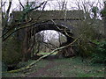
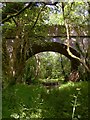
Road bridge in Cwm Brandy
A remarkably stout bridge carries a narrow lane across the valley; someone has taken the opportunity of using the arch to store firewood.
The reason for the construction of the bridge in 1908 was part of a scheme to replace the existing railway line between Letterston and Goodwick, the gradient of which was proving problematic. The cut-off, running beneath this bridge and south through Manorowen Wood, would have been easier but the work was never completed owing to the outbreak of WW1, and not required by post-war railway engines.
Image: © Natasha Ceridwen de Chroustchoff
Taken: 8 Feb 2008
0.11 miles
4
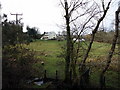
Mill Farm
View from the embankment planned for an alternative railway route that was never completed. There was more than one mill in this valley running down into Goodwick.
Image: © Natasha Ceridwen de Chroustchoff
Taken: 3 Feb 2011
0.12 miles
5
Bridge across a railway line which never was
The story - as told to ceridwen http://www.geograph.org.uk/profile/6699 by the local historian Roy Lewis - is that early in the 20th century the GWR started work on a new approach route to its terminus at Fishguard harbour, along an alignment with easier gradients. Work on the new route was at an advanced stage when war intervened in 1914. From what ceridwen was able to show me I would guess that all of the basic engineering was complete, and little remained to be done other than laying the track and installing signalling.
For whatever reason the project was not proceeded with post-war. Perhaps the reason was shortage of manpower, perhaps it was that the modern locomotive stud introduced by GJ Churchward coped better with the gradients of the existing route.
I have to thank ceridwen for alerting me to the existence of this line, and for navigating to this rather out of the way spot.
Image: © Stefan Czapski
Taken: 23 Jun 2011
0.12 miles
6
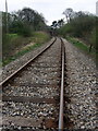
Railway south of Goodwick
Part of the stretch of line that caused problems owing to the gradient: the intention was to replace it with a cut-off between Goodwick and Mathry Road lying slightly to the east at a lower level. The project was started but abandoned at the start of WW1.
Image: © Natasha Ceridwen de Chroustchoff
Taken: 1 Apr 2009
0.17 miles
7
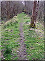
Path along an embankment
The embankment here was constructed for a stretch of railway line that was never completed, from Goodwick station through Manorowen woods toward Letterston.
Image: © Natasha Ceridwen de Chroustchoff
Taken: 1 Apr 2009
0.21 miles
9
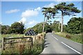
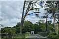
Approaching the Bridge, Manorowen
The A487 crosses the railway just past the two trees.
Image: © Des Blenkinsopp
Taken: 6 Aug 2024
0.22 miles
10
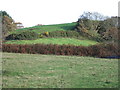
Parc Castell/Castell Fartin, Cwm Brandy
This mound is marked on the OS map as an earthwork and is recorded on the register of ancient monuments as ?iron age/?mediaeval. However other authorities suggest it is of Norman origin see http://www.castlewales.com/mnrown.html
The first name means castle field but the alternative name Castell Fartin neans Martin's Castle, supposedly because it was built by the Norman knight Martin Turribus. It lies towards the head of the valley that divides the twins towns of Fishguard and Goodwick.
Image: © Natasha Ceridwen de Chroustchoff
Taken: 9 Nov 2006
0.22 miles