IMAGES TAKEN NEAR TO
FISHGUARD, SA65 9PS
Introduction
This page details the photographs taken nearby to SA65 9PS by members of the Geograph project.
The Geograph project started in 2005 with the aim of publishing, organising and preserving representative images for every square kilometre of Great Britain, Ireland and the Isle of Man.

There are currently over 7.5m images from over14,400 individuals and you can help contribute to the project by visiting https://www.geograph.org.uk
Image Map (Loading...)


Getting Data...Please wait
Leaflet Map data © OpenStreetMap
Images are licensed for reuse under creativecommons.org/licenses/by-sa/2.0
Notes
- Clicking on the map will re-center to the selected point.
- The higher the marker number, the further away the image location is from the centre of the postcode.
Image Listing (14 Images Found)
Images are licensed for reuse under creativecommons.org/licenses/by-sa/2.0
Image
Details
Distance
1
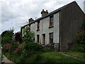
Cottages in Cwm Brandy
Short row of terraced cottages in this secluded valley between the 'twin towns'.
Image: © Natasha Ceridwen de Chroustchoff
Taken: 17 Jun 2008
0.02 miles
2
Cwm Brandy
This quiet, leafy valley between the 'twin towns' of Fishguard and Goodwick may owe its name to the fact that it would have provided a convenient route for contrabrand brought up from the shore along shady tracks to the turnpike road above.
Image: © Natasha Ceridwen de Chroustchoff
Taken: 6 Feb 2007
0.02 miles
3
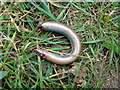
It wasn't fast enough!
A slow worm (Anguis fragilis) has been severed in half, probably by a bird. It may have been caught when it was still sluggish after emerging from hibernation. Although slow worms, like other lizards, can shed their tails to escape capture, this one was too severely wounded to survive.
Image: © Natasha Ceridwen de Chroustchoff
Taken: 1 Apr 2009
0.04 miles
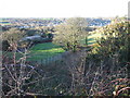
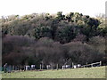
4
Cwm Brandy beyond the by-pass
The by-pass was cut through the sloping land between Bigney Hill and Cwm Brandy which is what we can see here, looking in a southwesterly direction. Cwm Brandy farm is on the left, and there are a few more houses tucked away in the valley.
Image: © Natasha Ceridwen de Chroustchoff
Taken: 11 Feb 2009
0.08 miles
5
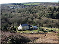
Smallholding in Cwm Brandy
Tucked away in the secluded valley between the 'twin towns' of Fishguard and Goodwick, this smallholding with poultry and bees, seems an idyllic spot. The valley floor is waterlogged and therefore it is unlikely that the trees will have to make way for houses. Lower down it becomes a wetland nature reserve.
Image: © Natasha Ceridwen de Chroustchoff
Taken: 11 Feb 2009
0.11 miles
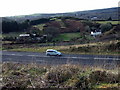
6
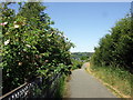
Cyclepath beside the by-pass
Fishguard by-pass is on the left.
Image: © Natasha Ceridwen de Chroustchoff
Taken: 24 Jun 2010
0.12 miles
7
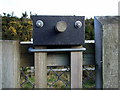
Face on a stile
The liftable section that allows dog to accompany their owners through the stile seems to possess its own friendly facial features.
Image: © Natasha Ceridwen de Chroustchoff
Taken: 11 Feb 2009
0.13 miles
8
Beehives in Cwm Brandy
A small apiary in a secluded setting.
Image: © Natasha Ceridwen de Chroustchoff
Taken: 11 Feb 2009
0.13 miles
9
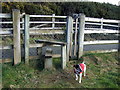
By-pass stile and dog gate
A sturdy stile and adjacent lift-up dog gate provides access to and from the pedestrian paths beside the by-pass. Some of these footways predate the new road.
Image: © Natasha Ceridwen de Chroustchoff
Taken: 11 Feb 2009
0.13 miles
10
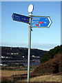
Bicycle route signpost
Cycleways meet and diverge with three possible directions: to St David's, to Cardigan or to the ferry port (visible in the background). The numbers in red refer to Sustrans routes.
Image: © Natasha Ceridwen de Chroustchoff
Taken: 11 Feb 2009
0.17 miles