IMAGES TAKEN NEAR TO
FISHGUARD, SA65 9PR
Introduction
This page details the photographs taken nearby to SA65 9PR by members of the Geograph project.
The Geograph project started in 2005 with the aim of publishing, organising and preserving representative images for every square kilometre of Great Britain, Ireland and the Isle of Man.

There are currently over 7.5m images from over14,400 individuals and you can help contribute to the project by visiting https://www.geograph.org.uk
Image Map (Loading...)


Getting Data...Please wait
Leaflet Map data © OpenStreetMap
Images are licensed for reuse under creativecommons.org/licenses/by-sa/2.0
Notes
- Clicking on the map will re-center to the selected point.
- The higher the marker number, the further away the image location is from the centre of the postcode.
Image Listing (17 Images Found)
Images are licensed for reuse under creativecommons.org/licenses/by-sa/2.0
Image
Details
Distance
1
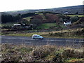
Cwm Brandy beyond the by-pass
The by-pass was cut through the sloping land between Bigney Hill and Cwm Brandy which is what we can see here, looking in a southwesterly direction. Cwm Brandy farm is on the left, and there are a few more houses tucked away in the valley.
Image: © Natasha Ceridwen de Chroustchoff
Taken: 11 Feb 2009
0.04 miles
2
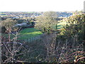
Cwm Brandy
This quiet, leafy valley between the 'twin towns' of Fishguard and Goodwick may owe its name to the fact that it would have provided a convenient route for contrabrand brought up from the shore along shady tracks to the turnpike road above.
Image: © Natasha Ceridwen de Chroustchoff
Taken: 6 Feb 2007
0.09 miles
3
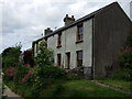
Cottages in Cwm Brandy
Short row of terraced cottages in this secluded valley between the 'twin towns'.
Image: © Natasha Ceridwen de Chroustchoff
Taken: 17 Jun 2008
0.10 miles
4
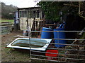
Rural clutter
The Cwm Brandy valley between Fishguard and Goodwick is patchwork of small fields and woods, gardens and rough grazing with equestrianism activities much in evidence.
Image: © Natasha Ceridwen de Chroustchoff
Taken: 8 Feb 2008
0.13 miles
5
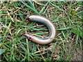
It wasn't fast enough!
A slow worm (Anguis fragilis) has been severed in half, probably by a bird. It may have been caught when it was still sluggish after emerging from hibernation. Although slow worms, like other lizards, can shed their tails to escape capture, this one was too severely wounded to survive.
Image: © Natasha Ceridwen de Chroustchoff
Taken: 1 Apr 2009
0.14 miles
6
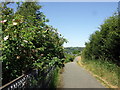
Cyclepath beside the by-pass
Fishguard by-pass is on the left.
Image: © Natasha Ceridwen de Chroustchoff
Taken: 24 Jun 2010
0.14 miles
7
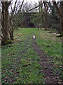
Path leading to the bridge
The path along the abandoned embankment, approaching the bridge seen here Image from the other direction.
Image: © Natasha Ceridwen de Chroustchoff
Taken: 1 Apr 2009
0.18 miles
8
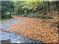
Entrance to Millbrook
A carpet of autumn leaves at the entrance to Millbrook.
Image: © Alan Hughes
Taken: 7 Nov 2017
0.19 miles
9
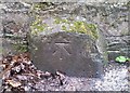
Ordnance Survey Cut Mark
This OS cut mark can be found on the NE parapet of the bridge. It marks a point 19.560m above mean sea level.
Image: © Adrian Dust
Taken: 4 Mar 2020
0.19 miles
10
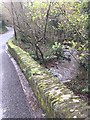
Bridge over Goodwick brook
Bridge over Goodwick brook near Mill farm.
Image: © Alan Hughes
Taken: 7 Nov 2017
0.19 miles