IMAGES TAKEN NEAR TO
Brodog Lane, FISHGUARD, SA65 9NT
Introduction
This page details the photographs taken nearby to Brodog Lane, SA65 9NT by members of the Geograph project.
The Geograph project started in 2005 with the aim of publishing, organising and preserving representative images for every square kilometre of Great Britain, Ireland and the Isle of Man.

There are currently over 7.5m images from over14,400 individuals and you can help contribute to the project by visiting https://www.geograph.org.uk
Image Map
Images are licensed for reuse under creativecommons.org/licenses/by-sa/2.0
Notes
- Clicking on the map will re-center to the selected point.
- The higher the marker number, the further away the image location is from the centre of the postcode.
Image Listing (415 Images Found)
Images are licensed for reuse under creativecommons.org/licenses/by-sa/2.0
Image
Details
Distance
1
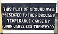
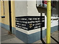
Reminder of the Temperance Movement in Fishguard
Located in what now is Theatr Gwaun.
Image: © Arthur C Harris
Taken: 24 Apr 2018
0.03 miles
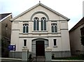
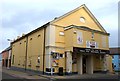
2

Theatr Gwaun
Fishguard's cinema (public and film club) since 1926, theatre (since 1994) and venue for other live entertainment. The W.I. country market also takes place here.
In its earlier incarnation (1881) it was a Temperance Hall.
Image: © Natasha Ceridwen de Chroustchoff
Taken: 31 Oct 2006
0.04 miles
3
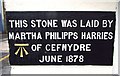
Lost cause in Fishguard
This stone betrays the original purpose of the building that is now Theatr Gwaun, temperance having given way to entertainment.
Image: © Natasha Ceridwen de Chroustchoff
Taken: 27 Oct 2007
0.04 miles
4
Bethel English Baptist Church, Fishguard
Bethel English Baptist Church,West Street,Fishguard.
Image: © Arthur C Harris
Taken: 5 Oct 2014
0.04 miles
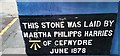
5
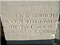
Stone in corner of Theatr Gwaun
Part of stone commemorating Temperance Movement in Fishguard.
Image: © Arthur C Harris
Taken: 24 Apr 2018
0.04 miles
6
Theatr Gwaun, Fishguard
4U Theatr Gwaun, West Street, Fishguard, a community run entertainment venue.
Image: © Arthur C Harris
Taken: 5 Oct 2014
0.04 miles
7
Foundation stone & benchmark on Theatr Gwaun (revisited)
I'd not realised I'd seen this one before Image but it's seen some alterations in the intervening 9 years, with a coat or two of paint and a general tidy-up of the presentation. The benchmark was levelled in 1987 at 61.066m above Ordnance Datum Newlyn.
Image: © Richard Law
Taken: 19 Sep 2019
0.05 miles
8
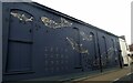
Theatr Gwaun mural
Theatr Gwaun's eye-catching mural was painted in 2021 by Grant Radford. Its theme is the maritime history and environment of the twin towns of Fishguard and Goodwick.
The mural was commissioned by Ancient Connections, a cross-border arts, heritage and tourism project, linking north Pembrokeshire and north Wexford, funded by the European Regional Development Fund.
Image: © Natasha Ceridwen de Chroustchoff
Taken: 24 Sep 2021
0.05 miles
9
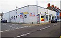
Nisa Extra, 52-54 West Street, Fishguard, Pembs
A large convenience store, independently owned, but a member of NISA.
Image: © P L Chadwick
Taken: 25 Jun 2017
0.05 miles
10
Ordnance Survey Cut Mark
This OS cut mark can be found on the south angle of the cinema. It marks a point 61.066m above mean sea level.
Image: © Adrian Dust
Taken: 4 Mar 2020
0.06 miles