IMAGES TAKEN NEAR TO
Newport Road, FISHGUARD, SA65 9ND
Introduction
This page details the photographs taken nearby to Newport Road, SA65 9ND by members of the Geograph project.
The Geograph project started in 2005 with the aim of publishing, organising and preserving representative images for every square kilometre of Great Britain, Ireland and the Isle of Man.

There are currently over 7.5m images from over14,400 individuals and you can help contribute to the project by visiting https://www.geograph.org.uk
Image Map (Loading...)


Getting Data...Please wait
Leaflet Map data © OpenStreetMap
Images are licensed for reuse under creativecommons.org/licenses/by-sa/2.0
Notes
- Clicking on the map will re-center to the selected point.
- The higher the marker number, the further away the image location is from the centre of the postcode.
Image Listing (292 Images Found)
Images are licensed for reuse under creativecommons.org/licenses/by-sa/2.0
Image
Details
Distance
1
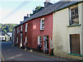
The Ship, Lower Town/Y Cwm
A pub with traditional interior which has not been 'messed about with'. It's located on the very narrow stretch of the A487, Newport Road and you fall straight out of the door into the main road.
Image: © Pauline E
Taken: 13 Sep 2009
0.01 miles
2
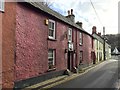
The Ship Inn
The Ship Inn, Lower Fishguard. According to the website gofishguard.co.uk "The Ship Inn is a roadside Ale House dating back to the late 18th Century, at the mouth of the River Gwaun in Lower Town< Fishguard. It has a long history, much of which is displayed in the vast collection of old maritime photographs and memorabilia in a marvellously unspoiled atmosphere."
Image: © Alan Hughes
Taken: 7 Nov 2017
0.01 miles
3
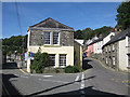
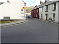
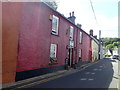
Lower Town's bottleneck
A bit of courtesy is needed to pass through this narrow stretch of the A487 as the road is only wide enough for one vehicle. And guess where the bus stop is?
The building in the centre was once a pub, The Dinas Arms. The left fork heads to the harbour and car park.
Image: © Pauline E
Taken: 12 Sep 2009
0.01 miles
4
A487 descends towards Fishguard Lower Town
Image: © Stuart Logan
Taken: 5 Oct 2011
0.01 miles
5
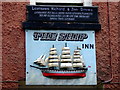
The Ship Inn sign
The coastal brig in low relief marks the pub in a narrow street where a hanging sign would be a hazard. For a model of a similar vessel up the coast see Image
Image: © Natasha Ceridwen de Chroustchoff
Taken: 17 Sep 2008
0.01 miles
6
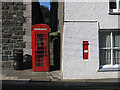
VR postbox and K6 phone box, Lower Town
Located near the former chapel.
Image: © Pauline E
Taken: 13 Sep 2009
0.01 miles
7
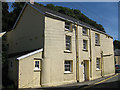
Former pub, Lower Town
Once the Dinas Arms, now a dwelling. The village still has one pub, The Ship.
Image: © Pauline E
Taken: 12 Sep 2009
0.01 miles
8
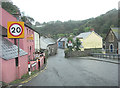
Looking north along Newport Road (A487)
This view shows how narrow the road is at this point. The white-painted house on the right was derelict.
Image: © John Baker
Taken: 24 Mar 2015
0.02 miles
9
The Ship Inn, Fishguard
A traditional fisherman's local, the Ship is one of the oldest buildings in Fishguard, dating back to around the 1780s.
Image: © Eirian Evans
Taken: 20 Jun 2019
0.02 miles
10
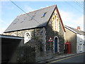
Former chapel, Lower Town
Now in use as a holiday let.
Image: © Pauline E
Taken: 13 Sep 2009
0.02 miles