IMAGES TAKEN NEAR TO
Glyn-y-Mel Road, FISHGUARD, SA65 9LY
Introduction
This page details the photographs taken nearby to Glyn-y-Mel Road, SA65 9LY by members of the Geograph project.
The Geograph project started in 2005 with the aim of publishing, organising and preserving representative images for every square kilometre of Great Britain, Ireland and the Isle of Man.

There are currently over 7.5m images from over14,400 individuals and you can help contribute to the project by visiting https://www.geograph.org.uk
Image Map
Images are licensed for reuse under creativecommons.org/licenses/by-sa/2.0
Notes
- Clicking on the map will re-center to the selected point.
- The higher the marker number, the further away the image location is from the centre of the postcode.
Image Listing (216 Images Found)
Images are licensed for reuse under creativecommons.org/licenses/by-sa/2.0
Image
Details
Distance
1
Old school room in the Cwm/Lower Town
Often referred to as a chapel, this little building was probably a small dame school. It was associated with the mansion of Plas Glynamel/Glynymel which lies a short distance beyond and I was told that its bell was rung to summon the estate workers to their midday meal. It has an interesting door carved by John Cleal and depsicting his family.
Image: © Natasha Ceridwen de Chroustchoff
Taken: 22 Aug 2007
0.02 miles
2
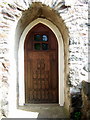
John Cleal's carved door
This door of an old chapel was made by the artist John Cleal and represents his own family. He took up residence in Lower Fishguard in the 1960's and ran a workshop and gallery and raised his children here, dying in 2007. He wrote:
"We must teach our children
To smell the Earth
To taste the rain
To touch the wind
To see things grow
To hear the sun rise and night fall
To care"
Image: © Natasha Ceridwen de Chroustchoff
Taken: 22 Aug 2007
0.05 miles
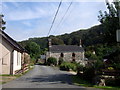
3
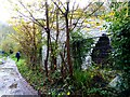
Former chapel, Glyn-y-mel Road
A no-through road in the wooded valley.
Image: © Pauline E
Taken: 14 Sep 2009
0.06 miles
4
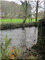
Afon Gwaun
The river is flowing to the left.
Image: © Derek Harper
Taken: 31 Dec 2014
0.06 miles
5
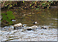
Dipper on the Afon Gwaun
Cinclus cinclus - the fast-flowing lower levels of the Afon Gwaun provide a perfect habitat for the dipper. http://www.rspb.org.uk/wildlife/birdguide/name/d/dipper/index.asp# and also http://en.wikipedia.org/wiki/Dipper
Image: © Pauline E
Taken: 18 Sep 2009
0.07 miles
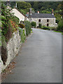
6
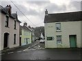
Junction, Lower Town
The A487 turns right here; Glyn-y-Mel Road continues straight ahead but is a no through road. The house on the left can be seen on the right of Image
Image: © Derek Harper
Taken: 31 Dec 2014
0.07 miles
7
Geese at the Cwm
A muddle of lobster pots, nets and other seagoing gear beside the bridge provides a safe haven for these geese.
Image: © Natasha Ceridwen de Chroustchoff
Taken: 4 Dec 2007
0.07 miles
8
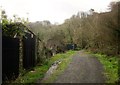
Footpath near Fishguard
Footpath PP19 62/1 heads along the Gwaun valley past these sheds.
Image: © Derek Harper
Taken: 31 Dec 2014
0.07 miles
9
Pistyll Hotch limekiln renewed
The once-derelict lime kiln beside the Afon Gwaun in the Mwsland area of Lower Fishguard has been beautifully rebuilt and renovated by a private individual. Worth a visit to see what can be done with neglected buildings of historical importance. Two other limekilns that were situated on the seaward side of the bridge were destroyed when the harbour area was improved. Those at the bottom of the Slade remain intact.
Image: © Natasha Ceridwen de Chroustchoff
Taken: 30 Oct 2020
0.07 miles
10
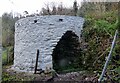
Pistyll Hotch lime kiln, Mwsland
Renovation more or less completed, the old lime kiln looks very striking. It bears the date 1800 on the east side. It is named for its position below the long-disused Pistyll Hotch quarries. Probably the boats supplying limestone for the kiln could load up with building stone in its stead.
Image: © Natasha Ceridwen de Chroustchoff
Taken: 14 Dec 2020
0.07 miles