IMAGES TAKEN NEAR TO
Heol Dyfed, FISHGUARD, SA65 9DR
Introduction
This page details the photographs taken nearby to Heol Dyfed, SA65 9DR by members of the Geograph project.
The Geograph project started in 2005 with the aim of publishing, organising and preserving representative images for every square kilometre of Great Britain, Ireland and the Isle of Man.

There are currently over 7.5m images from over14,400 individuals and you can help contribute to the project by visiting https://www.geograph.org.uk
Image Map
Images are licensed for reuse under creativecommons.org/licenses/by-sa/2.0
Notes
- Clicking on the map will re-center to the selected point.
- The higher the marker number, the further away the image location is from the centre of the postcode.
Image Listing (59 Images Found)
Images are licensed for reuse under creativecommons.org/licenses/by-sa/2.0
Image
Details
Distance
1
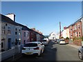
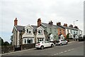
Maternal memories of happy holidays long ago
My mum spent happy times in Fishguard as a child. Her aunt's best friend lived in the light blue house on the left until her death.
Image: © Basher Eyre
Taken: 28 Aug 2019
0.02 miles
2
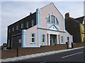
Masonic temple, Fishguard
Imposing, stucco-fronted building (1925) in Heol Dewi on the hill leading down to/up from Goodwick Parrog.
Image: © Natasha Ceridwen de Chroustchoff
Taken: 17 Aug 2007
0.05 miles
3
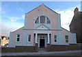
Masonic Temple, Fishguard
Dating from the 1920's, the Masonic Temple, Fishguard, Pembrokeshire.
Image: © Arthur C Harris
Taken: 13 Oct 2013
0.05 miles
4
Coastguard Cottages, Fishguard
These six cottages in the Windy Hall part of town were associated with the Coastguard Station close by. The largest one (nearest the camera) was allocated to the head coastguard. They all had long gardens behind.
Image: © Natasha Ceridwen de Chroustchoff
Taken: 23 Sep 2023
0.08 miles
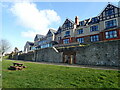
5
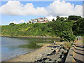
St Theresa's Convent and care home above Fishguard Harbour
Image: © Jonathan Thacker
Taken: 2 Jul 2015
0.08 miles
6
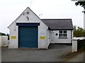
Fishguard coastguard/Gwylwyr y Glannau
This small building, which stands just off the road at the northwestern edge of the town, is the base for a team of 12 which covers an area from Porthgain to the beach at Newport, supporting full-time coastguards and volunteer life-boat crews in emergencies such as locating and rescuing missing people.
It is one of about 400 around the UK and although members have a variety of full-time day jobs they are on-call around-the-clock, every day of the year.
In 2007 the Fishguard team was instrumental in instituting liability insurance for volunteers following the injury of one of its members in the course of his duties. Hitherto the unpaid coastguards have had no disability compensation and their action, which involved threatening to turn off their pagers, has benefited all.
Image: © Natasha Ceridwen de Chroustchoff
Taken: 6 Jan 2007
0.08 miles
7
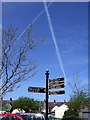
New signing in Fishguard
West Street carpark has one of the new signposts aimed at directing visitors to points of interest around the town.
Image: © Natasha Ceridwen de Chroustchoff
Taken: 2 May 2009
0.09 miles
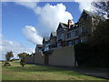
8
St Teresa's Rest Home, Fishguard
A Residential Home owned by The Sisters of Mercy whose special work is to teach, care for the sick/elderly, give shelter to the homeless, visit prisoners etc. The Sisters were founded in Ireland in 1831 by a young woman called Catherine McAuley. The Rest Home overlooks the Harbour and Goodwick beach. The Marine Walk, part of the coastal path, runs directly in front of the Home.
Image: © Eirian Evans
Taken: 3 Apr 2022
0.09 miles
9
St Teresa's Convent
The Sisters of Mercy provide a carehome and other services in this spot which is called Windy Hall (the name, one assumes, derives from the clifftop location and not the diet.)
Image: © Natasha Ceridwen de Chroustchoff
Taken: 6 Jan 2007
0.09 miles