IMAGES TAKEN NEAR TO
Erw Las, FISHGUARD, SA65 9BS
Introduction
This page details the photographs taken nearby to Erw Las, SA65 9BS by members of the Geograph project.
The Geograph project started in 2005 with the aim of publishing, organising and preserving representative images for every square kilometre of Great Britain, Ireland and the Isle of Man.

There are currently over 7.5m images from over14,400 individuals and you can help contribute to the project by visiting https://www.geograph.org.uk
Image Map (Loading...)


Getting Data...Please wait
Leaflet Map data © OpenStreetMap
Images are licensed for reuse under creativecommons.org/licenses/by-sa/2.0
Notes
- Clicking on the map will re-center to the selected point.
- The higher the marker number, the further away the image location is from the centre of the postcode.
Image Listing (138 Images Found)
Images are licensed for reuse under creativecommons.org/licenses/by-sa/2.0
Image
Details
Distance
1
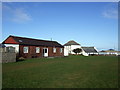
Old school and bunkhouse
The white building is now Fishguard's community education centre but was once the intermediate school. The "bunkhouse", as it is called, is a venue for meetings and clubs on what must once have been the school's playing field.
Image: © Natasha Ceridwen de Chroustchoff
Taken: 11 Feb 2009
0.04 miles
2
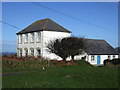
Former intermediate school, Fishguard
The old school was turned into Fishguard community education centre and is accessed from the back, the result being that one rarely sees its frontage.
An old postcard view shows that it was once an imposing sight perched up above the town before present-day infill housing.
It was replaced with the new junior school in 2011.
Image: © Natasha Ceridwen de Chroustchoff
Taken: 11 Feb 2009
0.05 miles
3
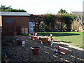
Gnome, sweet gnome
Signs of a serious gnome infestation in this tidy little garden!
Image: © Natasha Ceridwen de Chroustchoff
Taken: 11 Feb 2009
0.05 miles
4
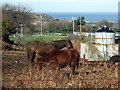
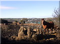
Horses and magpies
Slim pickings for the horses in this grassless paddock, although they had hay supplied. The magpies (left) seemed to be finding plenty to peck at however.
Below lie Fishguard High School's pitches bounded by the new access road from West Street. The red funnel of the ferry to Rosslare is visible in the harbour.
Image: © Natasha Ceridwen de Chroustchoff
Taken: 11 Feb 2009
0.06 miles
5
Horses with hay
...and not much else in this muddy paddock on Fishguard's higher slopes. The distant view is of the Stop-and-Call area of Goodwick while the blue-green colour in the mid-ground is not sea but the roof of the leisure centre.
Image: © Natasha Ceridwen de Chroustchoff
Taken: 11 Feb 2009
0.08 miles
6
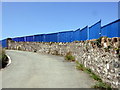
Blue fence
The area below the community education centre is currently a building site.
Image: © Natasha Ceridwen de Chroustchoff
Taken: 24 Jun 2010
0.10 miles
7
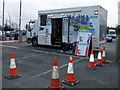
Road safety testing
This County Council mobile unit in West Street car park was offering free safety checks on child seats: it turned out less than 15% were correctly fitted.
Image: © Natasha Ceridwen de Chroustchoff
Taken: 8 Feb 2008
0.11 miles
8
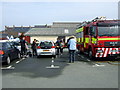
Charity car wash in West Street carpark
The local fire brigade trains its hoses on customers' vehicles.
Image: © Natasha Ceridwen de Chroustchoff
Taken: 10 Apr 2010
0.11 miles
9
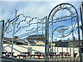
The Seagulls
Nice wrought ironwork for the entrance to Fishguard and Goodwick rugby football club from West Street carpark. The premises in West Street was formerly a pub.
Image: © Natasha Ceridwen de Chroustchoff
Taken: 8 Aug 2008
0.11 miles
10
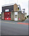
Fishguard Fire Station and drill tower, Clive Road, Fishguard, Pembs
The station was built about 1974, replacing an earlier one on the same site. It is managed by the Mid and West Wales Fire & Rescue Service. The station is crewed by On Call Firefighters, who respond to the station when required.
Image: © P L Chadwick
Taken: 25 Jun 2017
0.12 miles