IMAGES TAKEN NEAR TO
West Street, FISHGUARD, SA65 9AL
Introduction
This page details the photographs taken nearby to West Street, SA65 9AL by members of the Geograph project.
The Geograph project started in 2005 with the aim of publishing, organising and preserving representative images for every square kilometre of Great Britain, Ireland and the Isle of Man.

There are currently over 7.5m images from over14,400 individuals and you can help contribute to the project by visiting https://www.geograph.org.uk
Image Map (Loading...)


Getting Data...Please wait
Leaflet Map data © OpenStreetMap
Images are licensed for reuse under creativecommons.org/licenses/by-sa/2.0
Notes
- Clicking on the map will re-center to the selected point.
- The higher the marker number, the further away the image location is from the centre of the postcode.
Image Listing (442 Images Found)
Images are licensed for reuse under creativecommons.org/licenses/by-sa/2.0
Image
Details
Distance
1
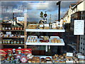
Cake shop reflections
The appetising window of Y Pantri, on the corner of Ropewalk and the Golden Mile,reflects the houses in Penslade (right), road signs, and hills beyond (left)
Image: © Natasha Ceridwen de Chroustchoff
Taken: 31 Oct 2006
0.00 miles
3
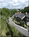
The Slade, Fishguard / Abergwaun
Slade (originally Slæd) is an Old English word meaning a valley; I have seen used in road names in Yorkshire and in Norfolk.
Image: © Humphrey Bolton
Taken: 2 Jul 2008
0.02 miles
4

Ropewalk
A ropeyard was established in Fishguard by Benjamin Williams in the mid-C18 and this street was used for stretching the ropes from the Ropeyard above, and sometimes even across West Street and all the way down the Slade (opposite Y Pantri.)
The process involved putting the yarn through a register plate to keep strands separate, thence passing them to the strand tube and keeping them tight to preserve the formation. This tube was attached to a hook on the forming machine and as it was pulled down the rope walk, a twist was put into the strand. Rope-making was an essential ancillary industry to boat building, fishing and sea-faring.
Image: © Natasha Ceridwen de Chroustchoff
Taken: 9 Jun 2010
0.02 miles
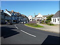
5
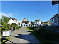
West Street, Fishguard
West Street bends outwards a little at this point, which allows space for a sliver of public garden.
Image: © Oliver Dixon
Taken: 15 Sep 2012
0.02 miles
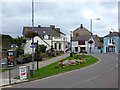
6
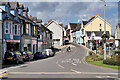
West Street in Fishguard, looking east in evening sun
Image: © Rob Purvis
Taken: 28 May 2022
0.02 miles
7
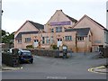
Fishguard Council School Centenary
The doors on this rather unpromising pink building on West Street are indelibly labelled "Boys" and "Girls" respectively.
Image: © Oliver Dixon
Taken: 15 Sep 2012
0.02 miles
8
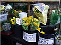
Local daffs
It seems as if the tulips are getting in on the act.
Image: © Natasha Ceridwen de Chroustchoff
Taken: 8 Feb 2008
0.02 miles
10
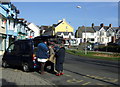
Fish van in the Golden Mile
The best source of fish in Fishguard is this van which visits twice weekly straight from the dock at Milford Haven.
Image: © Natasha Ceridwen de Chroustchoff
Taken: 1 Apr 2008
0.02 miles