IMAGES TAKEN NEAR TO
CLARBESTON ROAD, SA63 4XH
Introduction
This page details the photographs taken nearby to SA63 4XH by members of the Geograph project.
The Geograph project started in 2005 with the aim of publishing, organising and preserving representative images for every square kilometre of Great Britain, Ireland and the Isle of Man.

There are currently over 7.5m images from over14,400 individuals and you can help contribute to the project by visiting https://www.geograph.org.uk
Image Map
Images are licensed for reuse under creativecommons.org/licenses/by-sa/2.0
Notes
- Clicking on the map will re-center to the selected point.
- The higher the marker number, the further away the image location is from the centre of the postcode.
Image Listing (5 Images Found)
Images are licensed for reuse under creativecommons.org/licenses/by-sa/2.0
Image
Details
Distance
1
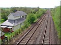
Deepford Crossing, Clarbeston
There was a level crossing here before the bridge was built. The house was the crossing-keeper's cottage.
Image: © Dylan Moore
Taken: 8 May 2008
0.06 miles
2
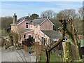
Railway Cottage
Fine-looking house alongside the railway line at Deepford Lane. But beware of the yappy dogs!
Image: © Alan Hughes
Taken: 7 Feb 2023
0.07 miles
5
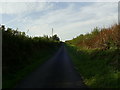
Deepford Lane near Clarbeston
Viewed from the bottom of the hill, north of the railway line, near Clarbeston. A narrow road with very few passing places.
Image: © Martyn Harries
Taken: 8 Oct 2010
0.19 miles