IMAGES TAKEN NEAR TO
CLARBESTON ROAD, SA63 4XB
Introduction
This page details the photographs taken nearby to SA63 4XB by members of the Geograph project.
The Geograph project started in 2005 with the aim of publishing, organising and preserving representative images for every square kilometre of Great Britain, Ireland and the Isle of Man.

There are currently over 7.5m images from over14,400 individuals and you can help contribute to the project by visiting https://www.geograph.org.uk
Image Map (Loading...)


Getting Data...Please wait
Leaflet Map data © OpenStreetMap
Images are licensed for reuse under creativecommons.org/licenses/by-sa/2.0
Notes
- Clicking on the map will re-center to the selected point.
- The higher the marker number, the further away the image location is from the centre of the postcode.
Image Listing (5 Images Found)
Images are licensed for reuse under creativecommons.org/licenses/by-sa/2.0
Image
Details
Distance
1
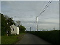
Road Junction near Clarbeston Road
The road junction can be seen beyond the house on the road to Wiston from Clarbeston Road. Turn left into Lamborough Lane.
Image: © Martyn Harries
Taken: 6 May 2012
0.03 miles
2
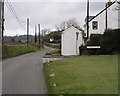
Lamborough lane
On the road to Clarbeston Road - just catches the corner of the grid!
Image: © Shaun Butler
Taken: 25 Feb 2009
0.04 miles
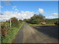
3
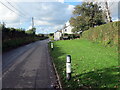
Ffordd i Heol Treglarbes / Road to Clarbeston Road
Ffordd yn mynd i gyfeiriad Heol Treglarbes.
A road heading towards Clarbeston Road.
Image: © Alan Richards
Taken: 27 Sep 2024
0.05 miles
4
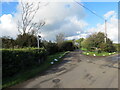
Llwybr yn gadael yr heol / Path exits the road
Llwybr troed cyhoeddus yn gadael heol fach.
A public footpath exits a minor road.
Image: © Alan Richards
Taken: 27 Sep 2024
0.17 miles
5
Llwybr yn gadael yr heol / Path exits the road
Llwybr troed cyhoeddus yn gadael heol fach wledig.
A public footpath exits a minor rural road.
Image: © Alan Richards
Taken: 27 Sep 2024
0.23 miles