IMAGES TAKEN NEAR TO
CLARBESTON ROAD, SA63 4UX
Introduction
This page details the photographs taken nearby to SA63 4UX by members of the Geograph project.
The Geograph project started in 2005 with the aim of publishing, organising and preserving representative images for every square kilometre of Great Britain, Ireland and the Isle of Man.

There are currently over 7.5m images from over14,400 individuals and you can help contribute to the project by visiting https://www.geograph.org.uk
Image Map (Loading...)


Getting Data...Please wait
Leaflet Map data © OpenStreetMap
Images are licensed for reuse under creativecommons.org/licenses/by-sa/2.0
Notes
- Clicking on the map will re-center to the selected point.
- The higher the marker number, the further away the image location is from the centre of the postcode.
Image Listing (55 Images Found)
Images are licensed for reuse under creativecommons.org/licenses/by-sa/2.0
Image
Details
Distance
1
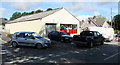
The Brooklyn Stores, Clarbeston Road
Off licence and general store on the corner of Brooklyn's Close http://www.geograph.org.uk/photo/4611101 in Clarbeston Road, a small village in Pembrokeshire.
Image: © Jaggery
Taken: 11 Aug 2015
0.01 miles
2
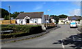
Brooklyn's Close, Clarbeston Road
Cul-de-sac in Clarbeston Road, a small village in Pembrokeshire.
Image: © Jaggery
Taken: 11 Aug 2015
0.02 miles
3
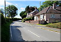
Brooklyn and Greenhill, Clarbeston Road
Two houses in the south of Clarbeston Road, a small village in Pembrokeshire.
Image: © Jaggery
Taken: 11 Aug 2015
0.04 miles
4
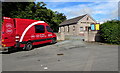
Mobile Post Office branch open for business in Clarbeston Road
In August 2015, the small Pembrokeshire village of Clarbeston Road has no permanent post office.
For two hours each morning from Monday-Friday, this mobile unit is open for business in the layby outside Bethany Free Church. http://www.geograph.org.uk/photo/4611091 I was pleasantly surprised at the range of items available inside, such as an envelope for depositing cheques for a Lloyds Bank account, and a selection of greetings cards.
Image: © Jaggery
Taken: 11 Aug 2015
0.05 miles
5
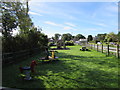
Children's playground in Clarbeston Road
Clarbeston Road is a small village in Pembrokeshire.
Image: © Jaggery
Taken: 11 Aug 2015
0.06 miles
6
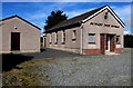
Bethany Free Church, Clarbeston Road
Founded in 1970, Bethany Free Church is an evangelical church in Clarbeston Road, a small village in Pembrokeshire.
Image: © Jaggery
Taken: 11 Aug 2015
0.06 miles
7
No dogs or bicycles allowed in the children's playground, Clarbeston Road
On the corner of Moorfield Crescent, near the entrance to this http://www.geograph.org.uk/photo/4611069
playground. Clarbeston Road is a small village in Pembrokeshire.
Image: © Jaggery
Taken: 11 Aug 2015
0.08 miles
8
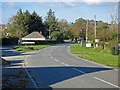
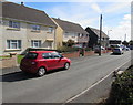
Clarbeston Road
The village is named after the railway station. Given that it's in the parish of Wiston, and it's on the road to Wiston, it's odd that it wasn't called Wiston Road.
Image: © Dylan Moore
Taken: 23 Oct 2016
0.09 miles
9
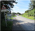
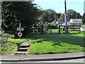
Wonky sign near a bus shelter in Clarbeston Road
The non-vertical sign is on the approach to this http://www.geograph.org.uk/photo/4611069 playground.
Clarbeston Road is a small village in Pembrokeshire.
Image: © Jaggery
Taken: 11 Aug 2015
0.10 miles
10
Moorfield Avenue, Clarbeston Road
Cul-de-sac in Clarbeston Road, a small village in Pembrokeshire.
Image: © Jaggery
Taken: 11 Aug 2015
0.10 miles