IMAGES TAKEN NEAR TO
Tufton, CLARBESTON ROAD, SA63 4UA
Introduction
This page details the photographs taken nearby to SA63 4UA by members of the Geograph project.
The Geograph project started in 2005 with the aim of publishing, organising and preserving representative images for every square kilometre of Great Britain, Ireland and the Isle of Man.

There are currently over 7.5m images from over14,400 individuals and you can help contribute to the project by visiting https://www.geograph.org.uk
Image Map (Loading...)


Getting Data...Please wait
Leaflet Map data © OpenStreetMap
Images are licensed for reuse under creativecommons.org/licenses/by-sa/2.0
Notes
- Clicking on the map will re-center to the selected point.
- The higher the marker number, the further away the image location is from the centre of the postcode.
Image Listing (6 Images Found)
Images are licensed for reuse under creativecommons.org/licenses/by-sa/2.0
Image
Details
Distance
1
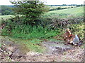
Oh well...(not St Brynach's)
If this is the well of St Brynach it's a sorry sight/site. The spring issuing from the ground in the farmyard of Bernard's Well (the Norman version of Brynach's name) has become a rubbish dump and paddling pool for cattle. It was not even possible to get close to examine it but an earlier photograph showed an incised ring cross in a stone above the water. There is supposed to have once been a chapel close by.
St Brynach was an important early Celtic saint who is commemorated at the nearby Henry's Moat church, and the hill to the north is known at St Bernard's mountain.
CORRECTION: this is NOT St Brynach's well! I am informed that is behind a nearby farm building and remains in better condition.
Image: © Natasha Ceridwen de Chroustchoff
Taken: 24 Jun 2007
0.04 miles
2
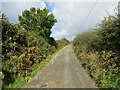
Hedge enclosed rack and footpath to St Bernard's Well
Looking north-westward.
Image: © Peter Wood
Taken: 8 Oct 2022
0.09 miles
3
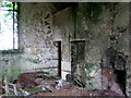
No more sitting on the old school bench...
At first this derelict building's high windows suggested a chapel but the fireplace and the remains of two rows of pegs at the height of roughly 3 and 4 feet told the story. Apart from this main room there was only a little teacher's office or store room behind. Numbers can never have been very high when the school served the local agricultural population and one can imagine that extreme weather conditions and the demands of the farming year would reduce the roll even more at times.
(As one who attended a rural school I can attest to the popularity of the desks closest to the fire in winter!)
Image: © Natasha Ceridwen de Chroustchoff
Taken: 24 Jun 2007
0.13 miles
4
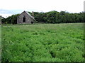
Ysgol Garn Ochor/Henry's Moat School
This tiny school room in the middle of nowhere is all but invisible from the road [left of the image] so overgrown has become the surrounding vegetation. All that remains is a dilapidated shell - it must have closed very many years ago - but the configuration of footpaths marked on the map indicate that its pupils would have trudged through the fields from all directions in this scattered rural community.
Update: The school was opened in 1877 and closed in 1953. At its peak it had 70 pupils but attendance was affected by the distances the children had to travel, as is shown by school records; illness also took its toll. The school was closely associated by nearby Ty Meini Farm whence came two of the teachers. Gardening was part of the syllabus and took place on the farm (free labour?!)
Not only did the children have to travel some distance but the head teacher appointed in 1912, a Mrs Bonvonni, bicycled from Trecwn, a distance of 6 miles (as the crow flies) and mostly up hill. Her annual salary was £139, almost 3 times that of an ordinary teacher.
(Information from 'Stories in Stone' by Anthony Bailey, quoting an article by Denzil Edwards in the Western Telegraph of 15th August 1989.)
The school has an eminent alumnus in the agricultural botanist Thomas James Jenkin (1885-1965), whose perennial ryegrass S.23 contributed immeasurably to the work of re-seeding productive pastures in the lowlands, sheepwalks and hill country from the 1930s onwards. see http://wbo.llgc.org.uk/en/s2-JENK-JAM-1885.html
Image: © Natasha Ceridwen de Chroustchoff
Taken: 24 Jun 2007
0.15 miles
5
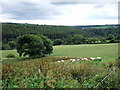
Cwm Syfynwy
View southwest from Bernard's Well down the valley of the Afon Syfynwy just before it enters the Llys-y-Fran reservoir around the bend.
Image: © Natasha Ceridwen de Chroustchoff
Taken: 24 Jun 2007
0.19 miles
6
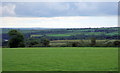
The long view
From the road above Bernard's Well farm the eye can encompass a large swathe of Pembrokeshire including, left, the top end of Llys-y-fran reservoir Image, right, the huge radio/TV mast at Woodstock Image, and straight ahead in the distance the oil refineries at Milford Haven.
Image: © Natasha Ceridwen de Chroustchoff
Taken: 24 Jun 2007
0.24 miles