IMAGES TAKEN NEAR TO
Tufton, CLARBESTON ROAD, SA63 4TT
Introduction
This page details the photographs taken nearby to SA63 4TT by members of the Geograph project.
The Geograph project started in 2005 with the aim of publishing, organising and preserving representative images for every square kilometre of Great Britain, Ireland and the Isle of Man.

There are currently over 7.5m images from over14,400 individuals and you can help contribute to the project by visiting https://www.geograph.org.uk
Image Map (Loading...)


Getting Data...Please wait
Leaflet Map data © OpenStreetMap
Images are licensed for reuse under creativecommons.org/licenses/by-sa/2.0
Notes
- Clicking on the map will re-center to the selected point.
- The higher the marker number, the further away the image location is from the centre of the postcode.
Image Listing (5 Images Found)
Images are licensed for reuse under creativecommons.org/licenses/by-sa/2.0
Image
Details
Distance
1
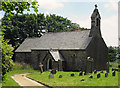
Parish Church: Henry's Moat
Dedicated to St Brynach of Nevern. Henry's Moat is Castell Hendre in Welsh.
Image: © Dylan Moore
Taken: 17 Jul 2013
0.02 miles
2
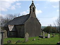
St Brynach's church
Another church dedicated to the Irish saint who founded a number of churches in this area (see here for example Image). It stands on the valley side in this now small hamlet close to the remains of a motte or earth castle, for which the place is named: Henry was not a person but a corruption of the Welsh name Castell Hendre (old castle settlement)
Image: © Natasha Ceridwen de Chroustchoff
Taken: 11 Apr 2007
0.02 miles
3
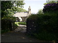
Churchyard gate, Henry's Moat
View from the lane to St Brynach's church and churchyard.
Image: © Martyn Harries
Taken: 9 Jun 2013
0.05 miles
4
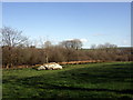
Boulder in field
A striking boulder or stone outcrop, not marked on the map.
This is a scattered hamlet of historical significance but now quiet and isolated.
Image: © Natasha Ceridwen de Chroustchoff
Taken: 7 Apr 2010
0.17 miles
5
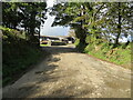
Minor road at Tymeini Farm, Henry's Moat
Looking westward.
Image: © Peter Wood
Taken: 8 Oct 2022
0.23 miles