IMAGES TAKEN NEAR TO
Tufton, CLARBESTON ROAD, SA63 4TP
Introduction
This page details the photographs taken nearby to SA63 4TP by members of the Geograph project.
The Geograph project started in 2005 with the aim of publishing, organising and preserving representative images for every square kilometre of Great Britain, Ireland and the Isle of Man.

There are currently over 7.5m images from over14,400 individuals and you can help contribute to the project by visiting https://www.geograph.org.uk
Image Map
Images are licensed for reuse under creativecommons.org/licenses/by-sa/2.0
Notes
- Clicking on the map will re-center to the selected point.
- The higher the marker number, the further away the image location is from the centre of the postcode.
Image Listing (1 Images Found)
Images are licensed for reuse under creativecommons.org/licenses/by-sa/2.0
Image
Details
Distance
1
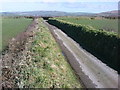
North view from Mount Pleasant
Narrow track with high banks either side, typical roads in rural Pembrokeshire. Western edge of Preseli mountains in far distance.
Image: © R Simpson
Taken: 15 Mar 2009
0.15 miles