IMAGES TAKEN NEAR TO
Tufton, CLARBESTON ROAD, SA63 4TN
Introduction
This page details the photographs taken nearby to SA63 4TN by members of the Geograph project.
The Geograph project started in 2005 with the aim of publishing, organising and preserving representative images for every square kilometre of Great Britain, Ireland and the Isle of Man.

There are currently over 7.5m images from over14,400 individuals and you can help contribute to the project by visiting https://www.geograph.org.uk
Image Map (Loading...)


Getting Data...Please wait
Leaflet Map data © OpenStreetMap
Images are licensed for reuse under creativecommons.org/licenses/by-sa/2.0
Notes
- Clicking on the map will re-center to the selected point.
- The higher the marker number, the further away the image location is from the centre of the postcode.
Image Listing (6 Images Found)
Images are licensed for reuse under creativecommons.org/licenses/by-sa/2.0
Image
Details
Distance
1
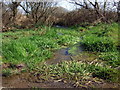
Watercourse near Ambleston
A nameless stream bubbles up by the road alongside the swampy edge of Wallis Moor.
Image: © Natasha Ceridwen de Chroustchoff
Taken: 7 Apr 2010
0.07 miles
2
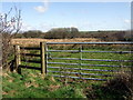
Path over Wallis Moor
A ROW is marked on the map leading from the road here in a southerly direction to Ambleston across the edge of the swampy area known as Wallis Moor. Eastwards can be seen the radar mast at Woodstock.
Image: © Natasha Ceridwen de Chroustchoff
Taken: 7 Apr 2010
0.12 miles
3
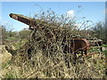
Abandoned elevator
Rusty old Lister elevator being gradually overtaken by bramble tentacles. Beside the road near Ambleston.
Image: © Natasha Ceridwen de Chroustchoff
Taken: 7 Apr 2010
0.13 miles
4
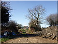
White Leys
Smallholding northeast of Ambleston. It lies just below the site of a Roman villa, Castle Flemish, marked on the OS map as 'enclosure'.
Image: © Natasha Ceridwen de Chroustchoff
Taken: 7 Apr 2010
0.17 miles
5
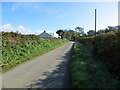
Hedge-lined minor road near Fleming's Castle
Looking eastward.
Image: © Peter Wood
Taken: 8 Oct 2022
0.17 miles
6
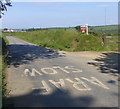
Araf = slow
Following years of campaigning by Cymdeithas yr Iaith Gymraeg (the Welsh Language Society), all road signs in Wales are now bi-lingual. Henne Lodge Farm is on the left. The hanging sign is for Stoney Hook Farm and the Image is in the distance on the right.
Image: © Roger W Haworth
Taken: 5 Jun 2007
0.19 miles