IMAGES TAKEN NEAR TO
Woodstock, CLARBESTON ROAD, SA63 4TH
Introduction
This page details the photographs taken nearby to SA63 4TH by members of the Geograph project.
The Geograph project started in 2005 with the aim of publishing, organising and preserving representative images for every square kilometre of Great Britain, Ireland and the Isle of Man.

There are currently over 7.5m images from over14,400 individuals and you can help contribute to the project by visiting https://www.geograph.org.uk
Image Map
Images are licensed for reuse under creativecommons.org/licenses/by-sa/2.0
Notes
- Clicking on the map will re-center to the selected point.
- The higher the marker number, the further away the image location is from the centre of the postcode.
Image Listing (5 Images Found)
Images are licensed for reuse under creativecommons.org/licenses/by-sa/2.0
Image
Details
Distance
1
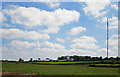
Big house, big sky: Bigws, Ambleston
Pigws actually means "little headland".
Image: © Dylan Moore
Taken: 17 Jul 2013
0.02 miles
2
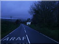
Araf (Slow) bend ahead on the B4329
Taken on a very dull afternoon, the painted Araf/Slow signs on the road surface warn the driver of a bend in the road beyond Bigws.
Image: © Martyn Harries
Taken: 15 Dec 2012
0.05 miles
3
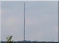
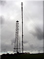
Mast
This is one Giant of a mast at Woodstock East Farm near Llys Y Fran Reservoir.
Image: © Cered
Taken: 22 Sep 2005
0.15 miles
4
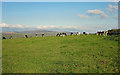
Cattle at Bigws, Ambleston
The horizon is dominated by Foel Cwmcerwyn. To the right are the stay cables of the Woodstock TV mast.
Image: © Dylan Moore
Taken: 23 Oct 2016
0.15 miles
5
Haverfordwest VHF-Transmitter
Another picture of this big mast but this being much closer.
The tower in front is very small only 40 feet when the main mast is 500 feet.
The mast is the main station VHF-FM Transmitter for this area when Preseli is the main TV-Transmitter.
Image: © David Neale
Taken: 25 Mar 2005
0.19 miles