IMAGES TAKEN NEAR TO
Walton East, CLARBESTON ROAD, SA63 4TA
Introduction
This page details the photographs taken nearby to SA63 4TA by members of the Geograph project.
The Geograph project started in 2005 with the aim of publishing, organising and preserving representative images for every square kilometre of Great Britain, Ireland and the Isle of Man.

There are currently over 7.5m images from over14,400 individuals and you can help contribute to the project by visiting https://www.geograph.org.uk
Image Map (Loading...)


Getting Data...Please wait
Leaflet Map data © OpenStreetMap
Images are licensed for reuse under creativecommons.org/licenses/by-sa/2.0
Notes
- Clicking on the map will re-center to the selected point.
- The higher the marker number, the further away the image location is from the centre of the postcode.
Image Listing (6 Images Found)
Images are licensed for reuse under creativecommons.org/licenses/by-sa/2.0
Image
Details
Distance
3
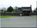
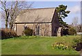
Parish Church and Bus Shelter, Walton East
The bus shelter is positioned by the widest part of the road in Walton East, in front of the church and churchyard.
Image: © Martyn Harries
Taken: 6 May 2012
0.19 miles
4
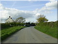
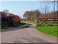
Entering Walton East
The entrance to The West can be seen beyond the speed limit and village signs.
Image: © Martyn Harries
Taken: 6 May 2012
0.20 miles
5
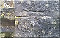
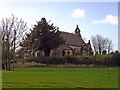
Ordnance Survey Cut Mark
This OS cut mark can be found on the NW angle of St Mary's Church. It marks a point 132.247m above mean sea level.
Image: © Adrian Dust
Taken: 27 Feb 2017
0.20 miles