IMAGES TAKEN NEAR TO
CLARBESTON ROAD, SA63 4SL
Introduction
This page details the photographs taken nearby to SA63 4SL by members of the Geograph project.
The Geograph project started in 2005 with the aim of publishing, organising and preserving representative images for every square kilometre of Great Britain, Ireland and the Isle of Man.

There are currently over 7.5m images from over14,400 individuals and you can help contribute to the project by visiting https://www.geograph.org.uk
Image Map (Loading...)


Getting Data...Please wait
Leaflet Map data © OpenStreetMap
Images are licensed for reuse under creativecommons.org/licenses/by-sa/2.0
Notes
- Clicking on the map will re-center to the selected point.
- The higher the marker number, the further away the image location is from the centre of the postcode.
Image Listing (3 Images Found)
Images are licensed for reuse under creativecommons.org/licenses/by-sa/2.0
Image
Details
Distance
1
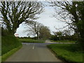
Road junction by Knock Farm
The entrance to Knock Farm can be seen from the road junction near Clarbeston Road.
Image: © Martyn Harries
Taken: 6 May 2012
0.10 miles
2
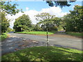
Arwydd fordd ar gyffordd T / Road sign at a T junction
Arwydd ffordd ar gyffordd T gyda mynedfa ffarm a llwybr troed cyhoeddus gyferbyn.
A road sign at a T junction with a farm access road and public footpath opposite.
Image: © Alan Richards
Taken: 27 Sep 2024
0.11 miles
3
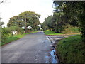
Cyffordd T / A T junction
Cyffordd T ar heol eitha tawel.
A T junction on a quiet road.
Image: © Alan Richards
Taken: 27 Sep 2024
0.24 miles