IMAGES TAKEN NEAR TO
New Moat, CLARBESTON ROAD, SA63 4RY
Introduction
This page details the photographs taken nearby to SA63 4RY by members of the Geograph project.
The Geograph project started in 2005 with the aim of publishing, organising and preserving representative images for every square kilometre of Great Britain, Ireland and the Isle of Man.

There are currently over 7.5m images from over14,400 individuals and you can help contribute to the project by visiting https://www.geograph.org.uk
Image Map
Images are licensed for reuse under creativecommons.org/licenses/by-sa/2.0
Notes
- Clicking on the map will re-center to the selected point.
- The higher the marker number, the further away the image location is from the centre of the postcode.
Image Listing (2 Images Found)
Images are licensed for reuse under creativecommons.org/licenses/by-sa/2.0
Image
Details
Distance
1
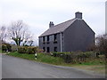
Parc Roberts
The cottage on the road between New Moat and Maenclochog looks unusual in that it has been covered in slates although not in the usual slate-hung fashion found in West Wales. This is in fact a recent addition but the original cottage originated as a simple one-storey 'ty-unnos' - a squatter's dwelling built directly upon the bedrock on common land.
Image: © Natasha Ceridwen de Chroustchoff
Taken: 15 Feb 2008
0.17 miles
2
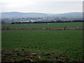
View from Parc Roberts
Zoomed image northeast across towards fields to Maenclochog with Mynydd Preseli behind.
Image: © Natasha Ceridwen de Chroustchoff
Taken: 15 Feb 2008
0.21 miles