IMAGES TAKEN NEAR TO
Llysyfran, CLARBESTON ROAD, SA63 4RP
Introduction
This page details the photographs taken nearby to SA63 4RP by members of the Geograph project.
The Geograph project started in 2005 with the aim of publishing, organising and preserving representative images for every square kilometre of Great Britain, Ireland and the Isle of Man.

There are currently over 7.5m images from over14,400 individuals and you can help contribute to the project by visiting https://www.geograph.org.uk
Image Map (Loading...)


Getting Data...Please wait
Leaflet Map data © OpenStreetMap
Images are licensed for reuse under creativecommons.org/licenses/by-sa/2.0
Notes
- Clicking on the map will re-center to the selected point.
- The higher the marker number, the further away the image location is from the centre of the postcode.
Image Listing (7 Images Found)
Images are licensed for reuse under creativecommons.org/licenses/by-sa/2.0
Image
Details
Distance
1
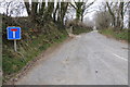
No through road at Gwastad
This no through road at Gwastad gives access to Brynteg.
Image: © Philip Halling
Taken: 7 Apr 2013
0.05 miles
2
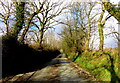
Looking north from Gwastad
Country lane on a sunny afternoon in February, running due north from Capel Gwastad.
Image: © Natasha Ceridwen de Chroustchoff
Taken: 11 Feb 2018
0.05 miles
3
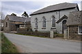
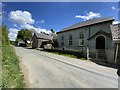
Chapel in Gwastad
Chapel in Gwastad near Llys-y-Frân.
Image: © Philip Halling
Taken: 7 Apr 2013
0.05 miles
4
Capel Gwastad Chapel
This view from the back complements Phillip Halling's shot from the road. The chapel, which was built in 1836, appears to be slate-hung on all sides but as there is a property jammed right up it wasn't possible to get closer. I was informed that the chapel is still used on a monthly basis and for funerals for its presumably ageing congregation in this very rural area, once a heartland of the Welsh Revival.
The chapel is distinguished by its association with local boy William 'Penfro' Rowlands composer of the famous hymn tune Blaenwern. Details about him can be found here http://daibach-welldigger.blogspot.com/2014/06/the-best-known-revival-hymn-tune.html
Image: © Natasha Ceridwen de Chroustchoff
Taken: 11 Feb 2018
0.05 miles
5
Gwastad Chapel
Gwastad Calvinistic Methodist Chapel.
Image: © Alan Hughes
Taken: 12 May 2020
0.05 miles
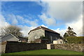
6
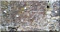
Ordnance Survey Cut Mark
This OS cut mark can be found on the north angle of the old school. It marks a point 130.963m above mean sea level.
Image: © Adrian Dust
Taken: 27 Feb 2017
0.05 miles
7
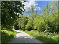
Woodland road
Road through woodland near Parcyreithin.
Image: © Alan Hughes
Taken: 12 May 2020
0.22 miles