IMAGES TAKEN NEAR TO
New Moat, CLARBESTON ROAD, SA63 4RE
Introduction
This page details the photographs taken nearby to SA63 4RE by members of the Geograph project.
The Geograph project started in 2005 with the aim of publishing, organising and preserving representative images for every square kilometre of Great Britain, Ireland and the Isle of Man.

There are currently over 7.5m images from over14,400 individuals and you can help contribute to the project by visiting https://www.geograph.org.uk
Image Map (Loading...)


Getting Data...Please wait
Leaflet Map data © OpenStreetMap
Images are licensed for reuse under creativecommons.org/licenses/by-sa/2.0
Notes
- Clicking on the map will re-center to the selected point.
- The higher the marker number, the further away the image location is from the centre of the postcode.
Image Listing (4 Images Found)
Images are licensed for reuse under creativecommons.org/licenses/by-sa/2.0
Image
Details
Distance
1
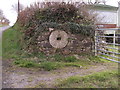
Redundant Mill stone
Nice use of a mill stone, Forehill Farm.
Image: © chris whitehouse
Taken: 3 Apr 2012
0.03 miles
2
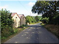
Heol ger Ffarm Forehill / Road near Forehill Farm
Heol yn mynd heibio i anhedd-dy ger Ffarm Forehill.
A road passing a property near Fore Hill Farm.
Image: © Alan Richards
Taken: 1 Aug 2021
0.03 miles
3
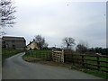
Forehill Farm
On the road south of New Moat. This area is below the Landsker line so most of the places names are non-Welsh.
Image: © Natasha Ceridwen de Chroustchoff
Taken: 15 Feb 2008
0.06 miles
4
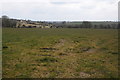
View to Forehill Farm
View to Forehill Farm to the south of New Moat.
Image: © Philip Halling
Taken: 7 Apr 2013
0.14 miles