IMAGES TAKEN NEAR TO
Solva, HAVERFORDWEST, SA62 6YD
Introduction
This page details the photographs taken nearby to SA62 6YD by members of the Geograph project.
The Geograph project started in 2005 with the aim of publishing, organising and preserving representative images for every square kilometre of Great Britain, Ireland and the Isle of Man.

There are currently over 7.5m images from over14,400 individuals and you can help contribute to the project by visiting https://www.geograph.org.uk
Image Map (Loading...)


Getting Data...Please wait
Leaflet Map data © OpenStreetMap
Images are licensed for reuse under creativecommons.org/licenses/by-sa/2.0
Notes
- Clicking on the map will re-center to the selected point.
- The higher the marker number, the further away the image location is from the centre of the postcode.
Image Listing (2 Images Found)
Images are licensed for reuse under creativecommons.org/licenses/by-sa/2.0
Image
Details
Distance
1
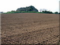
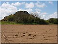
Uluru in Pembrokeshire?
Well, not quite perhaps, but the prominent contour of Carn Treglemaes rising out of the flat landscape east of St David's is, to me, immediately reminiscent of Uluru (Ayer's Rock) in Australia. It is an erratic outcrop with no associated prehistoric remains although it may be significant that there are a couple of archaeological sites nearby.
Image: © Natasha Ceridwen de Chroustchoff
Taken: 5 May 2007
0.18 miles