IMAGES TAKEN NEAR TO
Solva, HAVERFORDWEST, SA62 6XJ
Introduction
This page details the photographs taken nearby to SA62 6XJ by members of the Geograph project.
The Geograph project started in 2005 with the aim of publishing, organising and preserving representative images for every square kilometre of Great Britain, Ireland and the Isle of Man.

There are currently over 7.5m images from over14,400 individuals and you can help contribute to the project by visiting https://www.geograph.org.uk
Image Map (Loading...)


Getting Data...Please wait
Leaflet Map data © OpenStreetMap
Images are licensed for reuse under creativecommons.org/licenses/by-sa/2.0
Notes
- Clicking on the map will re-center to the selected point.
- The higher the marker number, the further away the image location is from the centre of the postcode.
Image Listing (6 Images Found)
Images are licensed for reuse under creativecommons.org/licenses/by-sa/2.0
Image
Details
Distance
1
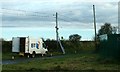
The Old Barn, Solva
Something Fishy going on here - the place to order fresh fish and shellfish
Image: © Eirian Evans
Taken: 28 Apr 2022
0.01 miles
2
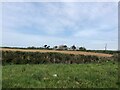
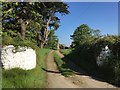
Road to Llandeloy and Penrhiw farm near Solva, Pembrokeshire
Image: © Jeff Gogarty
Taken: 3 Oct 2020
0.05 miles
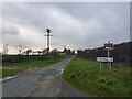
4
Trecadwgan Farm
Entrance to Trecadwgan Farm.
Image: © Alan Hughes
Taken: 25 May 2017
0.14 miles
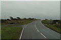
5
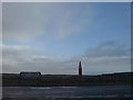
Boring road junction!
Obviously not a first but what else could I take to claim this geograph square?!
Nil points for creativity!
Image: © Deborah Tilley
Taken: 26 Jan 2009
0.15 miles