IMAGES TAKEN NEAR TO
The Quick, HAVERFORDWEST, SA62 6UP
Introduction
This page details the photographs taken nearby to The Quick, SA62 6UP by members of the Geograph project.
The Geograph project started in 2005 with the aim of publishing, organising and preserving representative images for every square kilometre of Great Britain, Ireland and the Isle of Man.

There are currently over 7.5m images from over14,400 individuals and you can help contribute to the project by visiting https://www.geograph.org.uk
Image Map (Loading...)


Getting Data...Please wait
Leaflet Map data © OpenStreetMap
Images are licensed for reuse under creativecommons.org/licenses/by-sa/2.0
Notes
- Clicking on the map will re-center to the selected point.
- The higher the marker number, the further away the image location is from the centre of the postcode.
Image Listing (327 Images Found)
Images are licensed for reuse under creativecommons.org/licenses/by-sa/2.0
Image
Details
Distance
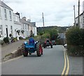
2
Circular walk from Solva to St Elvis and Dinas Fawr (3)
This series of photos portrays a 2-mile circular walk east and south of Solva, Pembrokeshire.
Initially, the walk climbs out of the valley of the River Solva onto The Gribbin, a knife-edge ridge between the glacial valleys of Solva and Gwadn. The walk then descends to a marshy area before climbing inland to farmland. Near St Elvis Farm, the walk passes a cromlech (a neolithic burial chamber) then heads to the coastpath and turns west to follow the clifftop. After descending into Gwadn cove, the walk climbs to rejoin The Gribbin before descending into Solva. The route can be followed on OS 1:50000 sheet 157 or on OS 'Explorer' 1:25000 sheet OL35.
Once the path has emerged onto The Gribbin ridge, there are fine views in all directions. This photo is looking west across the valley towards Upper Solva village.
Previous [http://www.geograph.org.uk/photo/1532646]
Next [http://www.geograph.org.uk/photo/1532655]
Image: © Andy F
Taken: 27 Sep 2009
0.04 miles
3
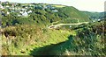
View of Upper Solva from the Gribin (1)
Image: © Jeff Gogarty
Taken: 23 Sep 2020
0.04 miles
4
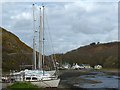
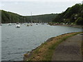
Yachts beside the River Solva at low tide
Image: © Robin Drayton
Taken: 23 Mar 2015
0.05 miles
5
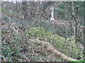
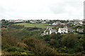
War Memorial at Solva
Situated by the side of the main road on the hill to Upper Solva, the photograph was taken from the footpath below which runs from the harbour to Pen yr Aber.
Image: © Deborah Tilley
Taken: 22 Feb 2008
0.05 miles
6
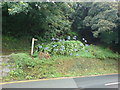
Amazing Agapanthus
There is a stunning display here on the roadside every summer of this lovely South African native.
Image: © Deborah Tilley
Taken: 19 Aug 2008
0.05 miles
9
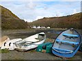
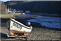
Rowing boats, Solva
On the north side of the River Solva.
Image: © Robin Drayton
Taken: 23 Mar 2015
0.06 miles