IMAGES TAKEN NEAR TO
Caerbwdi, St. Davids, HAVERFORDWEST, SA62 6QP
Introduction
This page details the photographs taken nearby to SA62 6QP by members of the Geograph project.
The Geograph project started in 2005 with the aim of publishing, organising and preserving representative images for every square kilometre of Great Britain, Ireland and the Isle of Man.

There are currently over 7.5m images from over14,400 individuals and you can help contribute to the project by visiting https://www.geograph.org.uk
Image Map (Loading...)


Getting Data...Please wait
Leaflet Map data © OpenStreetMap
Images are licensed for reuse under creativecommons.org/licenses/by-sa/2.0
Notes
- Clicking on the map will re-center to the selected point.
- The higher the marker number, the further away the image location is from the centre of the postcode.
Image Listing (48 Images Found)
Images are licensed for reuse under creativecommons.org/licenses/by-sa/2.0
Image
Details
Distance
1
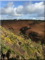
Gorse, Bracken and Sky
A view from the Pembrokeshire footpath across a gorse and bracken clad valley, towards the cottage of Penrallt, Caerbwdy. Look closely and you can see near the centre of the picture a small stone-arched footbridge crossing the Caerbwdy stream, with a Waymarker just to the right.
Image: © Alan Hughes
Taken: 10 Nov 2016
0.00 miles
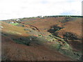
2
Houses overlooking Caer Bwdy Bay
Viewed from the Pembrokeshire Coast Path.
Image: © Mat Fascione
Taken: 5 Jun 2019
0.05 miles
3
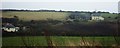
Houses Near Trelerw
As seen from across the valley at Carn-Nwchwn
Image: © Deborah Tilley
Taken: 4 Feb 2016
0.06 miles
4
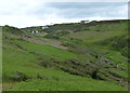
Tegfan and Penrallt
View across the valley from Carn Nwchwn, which used to be the lands belonging to the Bishop of St Davids.
Image: © Deborah Tilley
Taken: 11 Feb 2011
0.06 miles
5
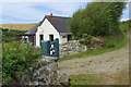
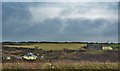
Agos-y-Mor
Agos-y-Mor ('near the sea') is a holiday cottage sleeping four in a lovely location above Caer Bwdy Bay. The track from the road ends here and there is just a path down to the beach.
Image: © Stephen McKay
Taken: 18 Jul 2019
0.07 miles
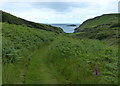
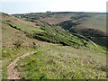
7
Valley above Caer Bwdy Bay
Seen from the Pembrokeshire Way footpath. The footpath down to the shore from the road can be clearly seen cutting through the bracken. The side wall of an old lime kiln can be seen near the centre of the photo and, to its right, the small bridge that carries the footpath over the stream.
Image: © E Gammie
Taken: 30 Sep 2016
0.11 miles
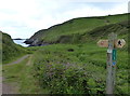
8
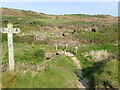
Footbridge and signpost at Caer Bwdy Bay
The remains of a cottage is just beyond the footbridge, where there used to be a corn mill
Image: © Eirian Evans
Taken: 29 Apr 2022
0.14 miles
10
Pembrokeshire Coast Path at Caer Bwdy Bay
Image: © Mat Fascione
Taken: 5 Jun 2019
0.14 miles