IMAGES TAKEN NEAR TO
Rhodiad, St. Davids, HAVERFORDWEST, SA62 6PN
Introduction
This page details the photographs taken nearby to SA62 6PN by members of the Geograph project.
The Geograph project started in 2005 with the aim of publishing, organising and preserving representative images for every square kilometre of Great Britain, Ireland and the Isle of Man.

There are currently over 7.5m images from over14,400 individuals and you can help contribute to the project by visiting https://www.geograph.org.uk
Image Map (Loading...)


Getting Data...Please wait
Leaflet Map data © OpenStreetMap
Images are licensed for reuse under creativecommons.org/licenses/by-sa/2.0
Notes
- Clicking on the map will re-center to the selected point.
- The higher the marker number, the further away the image location is from the centre of the postcode.
Image Listing (8 Images Found)
Images are licensed for reuse under creativecommons.org/licenses/by-sa/2.0
Image
Details
Distance
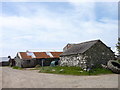
1
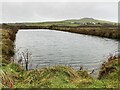
Llanferran and Carn Trellwyd
View across pond towards Llanferran and Carn Trellwyd.
Image: © Alan Hughes
Taken: 17 Nov 2020
0.07 miles
2
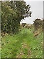
Green lane
Old farm track between Llanferran and Treleidr.
Image: © Alan Hughes
Taken: 17 Nov 2020
0.11 miles
3
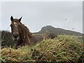
View across a grassy bank
A curious interloper is wondering why anyone should want to photograph Penberry.
Image: © Alan Hughes
Taken: 17 Nov 2020
0.11 miles
4

Treleidr with Penberi
Looking due north from a back lane NNE of St David's, this zoomed view across the fields brings into focus the farm of Treleidr with the craggy eminence of Penberi looming above, its lower slopes clothed in bracken.
Treleidr is one of several large farms, mentioned in the C14 Black Book of St David's and most beginning with 'Tre-' , that give their names to the small settlements clustered around. In the middle ages they were semi-manorial, held by a version of Welsh custom in which an infield-outfield system was practised, where land was held not by individual ownership, but by two persons and their co-owners.
Penberi is an extrusion of igneous rock from whose summit stunning views of the sea, coast and inland landscape are to be had.
Image: © Natasha Ceridwen de Chroustchoff
Taken: 22 Jul 2007
0.14 miles
6
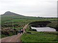
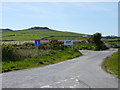
Heol Ffarm Llanfferan Farm Road
Cerddwyr yn rhodio ar hyd heol a arwain at Ffarm Llanferran. Y graig yn y pellter yw Carn Pen Berry.
Walkers following Llanferran Farm access road. In the distance is a rocky hill known as Carn Pen Berry.
Image: © Alan Richards
Taken: 25 May 2014
0.23 miles
7
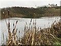
Pond and reeds
Pool at Llanferran Farm.
Image: © Alan Hughes
Taken: 17 Nov 2020
0.23 miles