IMAGES TAKEN NEAR TO
Quickwell, HAVERFORDWEST, SA62 6PD
Introduction
This page details the photographs taken nearby to Quickwell, SA62 6PD by members of the Geograph project.
The Geograph project started in 2005 with the aim of publishing, organising and preserving representative images for every square kilometre of Great Britain, Ireland and the Isle of Man.

There are currently over 7.5m images from over14,400 individuals and you can help contribute to the project by visiting https://www.geograph.org.uk
Image Map (Loading...)


Getting Data...Please wait
Leaflet Map data © OpenStreetMap
Images are licensed for reuse under creativecommons.org/licenses/by-sa/2.0
Notes
- Clicking on the map will re-center to the selected point.
- The higher the marker number, the further away the image location is from the centre of the postcode.
Image Listing (960 Images Found)
Images are licensed for reuse under creativecommons.org/licenses/by-sa/2.0
Image
Details
Distance
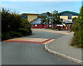
1
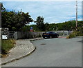
Quickwell Hill entrance to Ysgol Bro Dewi, St David's
A 5mph speed limit and one-way traffic system are in force here.
The red sign shows NO PUBLIC RIGHT OF WAY.
Ysgol Bro Dewi is a Church in Wales Voluntary Aided Primary School.
Image: © Jaggery
Taken: 21 Jul 2014
0.01 miles
2
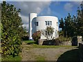
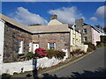
Round House, St David's, Pembrokeshire
Built for E W Parke, Professor of Engineering at Leicester University by James Gowan of the Stirling and Gowan architectural partnership.
Image: © Jeff Gogarty
Taken: 18 Sep 2022
0.02 miles
3
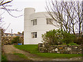
The Round House, St David's
Built 1965 or soon after as a holiday home. Listed, Grade II.
Image: © Humphrey Bolton
Taken: 29 Aug 2020
0.03 miles
4
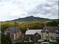
Quickwell Hill, St David's with Carn Llidi in the distance
Image: © Jeff Gogarty
Taken: 2 Oct 2019
0.03 miles
5
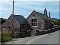
Grade II listed former school in St David's
Viewed across Quickwell Hill. The building dating from 1873 was Grade II listed in 1981.
http://www.geograph.org.uk/photo/4112647 to another view. An entrance road http://www.geograph.org.uk/photo/4112551 to the present-day school is nearby.
Image: © Jaggery
Taken: 21 Jul 2014
0.03 miles
7
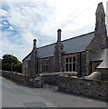
Former school in St David's
The Quickwell Hill building dating from 1873 was Grade II listed in 1981. http://www.geograph.org.uk/photo/4112608 to another view.
An entrance road http://www.geograph.org.uk/photo/4112551 to the present-day school is nearby.
Image: © Jaggery
Taken: 21 Jul 2014
0.04 miles
8
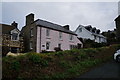
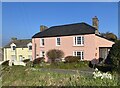
Cottages on Quickwell Hill, St David's
Most of these are holiday lets.
Image: © Jeff Gogarty
Taken: 18 Sep 2022
0.04 miles
10
Ysgol Bro Dewi, St David's
Viewed from the Nun Street entrance gates. http://www.geograph.org.uk/photo/4103462
Ysgol Bro Dewi is a Church in Wales Voluntary Aided Primary School.
Image: © Jaggery
Taken: 21 Jul 2014
0.04 miles