IMAGES TAKEN NEAR TO
Camrose, HAVERFORDWEST, SA62 6JQ
Introduction
This page details the photographs taken nearby to SA62 6JQ by members of the Geograph project.
The Geograph project started in 2005 with the aim of publishing, organising and preserving representative images for every square kilometre of Great Britain, Ireland and the Isle of Man.

There are currently over 7.5m images from over14,400 individuals and you can help contribute to the project by visiting https://www.geograph.org.uk
Image Map (Loading...)


Getting Data...Please wait
Leaflet Map data © OpenStreetMap
Images are licensed for reuse under creativecommons.org/licenses/by-sa/2.0
Notes
- Clicking on the map will re-center to the selected point.
- The higher the marker number, the further away the image location is from the centre of the postcode.
Image Listing (6 Images Found)
Images are licensed for reuse under creativecommons.org/licenses/by-sa/2.0
Image
Details
Distance
1
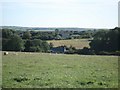
Wolfsdale Pit
Curious name for a dwelling. I couldn't see any evidence of mining.
Image: © Deborah Tilley
Taken: 22 Mar 2009
0.09 miles
2
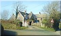
Folly Cross near Camrose
Five-way crossroads north of Camrose. It's tempting to speculate that the house facing was once a pub but I can find no confirmation of that.
Image: © Natasha Ceridwen de Chroustchoff
Taken: 31 Dec 2009
0.15 miles
3
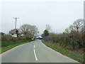
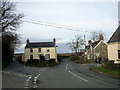
Bend in the B4330, Folly Cross
The view of the bend in the B4330 approaching Folly Cross near Camrose.
Image: © Martyn Harries
Taken: 9 Mar 2012
0.20 miles
4
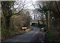
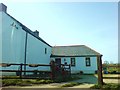
Wolfsdale bridge near Camrose
Small bridge over a stream which is nameless on the OS map. There is a sewage pumping station to the right of the bridge.
Image: © Natasha Ceridwen de Chroustchoff
Taken: 31 Dec 2009
0.21 miles