IMAGES TAKEN NEAR TO
Roch, HAVERFORDWEST, SA62 6HE
Introduction
This page details the photographs taken nearby to SA62 6HE by members of the Geograph project.
The Geograph project started in 2005 with the aim of publishing, organising and preserving representative images for every square kilometre of Great Britain, Ireland and the Isle of Man.

There are currently over 7.5m images from over14,400 individuals and you can help contribute to the project by visiting https://www.geograph.org.uk
Image Map
Images are licensed for reuse under creativecommons.org/licenses/by-sa/2.0
Notes
- Clicking on the map will re-center to the selected point.
- The higher the marker number, the further away the image location is from the centre of the postcode.
Image Listing (7 Images Found)
Images are licensed for reuse under creativecommons.org/licenses/by-sa/2.0
Image
Details
Distance
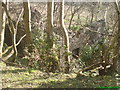
3
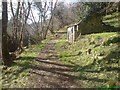
Ruin of New Mill on Brandy Brook near Roch
One of a few old ruins on the river in a decrepit state. In a beautiful setting facing East and surrounded by old trees at the foot of a steep hill. It is situated on a path winding its way through the remains of an Ice Age river valley.
Image: © Deborah Tilley
Taken: 27 Mar 2008
0.11 miles
4
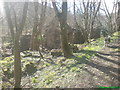
Ruin of New Mill on Brandy Brook near Roch
Another building in a ruinous state.
Image: © Deborah Tilley
Taken: 27 Mar 2008
0.11 miles
5
Another ruin of the New Mill at Brandy Brook
Image: © Deborah Tilley
Taken: 27 Mar 2008
0.11 miles
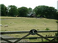
6
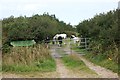
Horses at the entrance to Coed y Barch
Image: © Simon Mortimer
Taken: 27 Aug 2013
0.17 miles
7
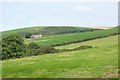
Valley of Brandy Brook south of Gignog
Looking north from just below Coed y Barch. The farm at Gignog can be seen in the distance.
Image: © Simon Mortimer
Taken: 27 Aug 2013
0.25 miles