IMAGES TAKEN NEAR TO
/Wayside Close, HAVERFORDWEST, SA62 6EP
Introduction
This page details the photographs taken nearby to /Wayside Close, SA62 6EP by members of the Geograph project.
The Geograph project started in 2005 with the aim of publishing, organising and preserving representative images for every square kilometre of Great Britain, Ireland and the Isle of Man.

There are currently over 7.5m images from over14,400 individuals and you can help contribute to the project by visiting https://www.geograph.org.uk
Image Map (Loading...)


Getting Data...Please wait
Leaflet Map data © OpenStreetMap
Images are licensed for reuse under creativecommons.org/licenses/by-sa/2.0
Notes
- Clicking on the map will re-center to the selected point.
- The higher the marker number, the further away the image location is from the centre of the postcode.
Image Listing (32 Images Found)
Images are licensed for reuse under creativecommons.org/licenses/by-sa/2.0
Image
Details
Distance
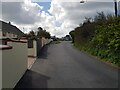
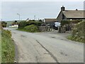
1

Haresfield, Simpson Cross
One of the older properties in this quite young village. Situated on the main road.
Image: © Deborah Tilley
Taken: 1 Oct 2008
0.03 miles
2
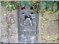
Ordnance Survey Flush Bracket 11508
This can be found on the wall of an old farm building at Kerrin Cottage.
For more detail see : http://www.bench-marks.org.uk/bm22523
Image: © Peter Wood
Taken: 19 May 2013
0.03 miles
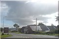
3
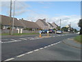
A487 to Haverfordwest
Passing through Simpson Cross.
Image: © Deborah Tilley
Taken: 20 Jul 2008
0.04 miles
4
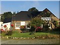
The Old Smithy, Simpson Cross
Art exhibition at the Old Smithy.
Image: © Alan Hughes
Taken: 14 Sep 2016
0.07 miles
5
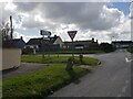
Simpson Cross
Approaching the crossroads at Simpson Cross.
Image: © Alan Hughes
Taken: 14 Nov 2021
0.08 miles
6
The Old Smithy
Probably the oldest building in the village. Renovated and extended some years ago, it is now a gift shop.
Image: © Deborah Tilley
Taken: 1 Oct 2008
0.09 miles
7

An abundance of old red phoneboxes
Simpson Cross has rather a lot of these old phoneboxes situated in gardens, usually growing tomatoes. How so many ended up in this village I do not know!
Image: © Deborah Tilley
Taken: 1 Oct 2008
0.09 miles
8
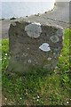
Boundary Stone
There is an Ordnance Survey cut mark on the stone which marks a point 110.777m above mean sea level.
Image: © Adrian Dust
Taken: 23 Apr 2017
0.09 miles
9
Crossroads at Simpson Cross (Cuffern side)
Image: © Jeff Gogarty
Taken: 8 Apr 2022
0.09 miles