IMAGES TAKEN NEAR TO
Berea, HAVERFORDWEST, SA62 6DL
Introduction
This page details the photographs taken nearby to SA62 6DL by members of the Geograph project.
The Geograph project started in 2005 with the aim of publishing, organising and preserving representative images for every square kilometre of Great Britain, Ireland and the Isle of Man.

There are currently over 7.5m images from over14,400 individuals and you can help contribute to the project by visiting https://www.geograph.org.uk
Image Map (Loading...)


Getting Data...Please wait
Leaflet Map data © OpenStreetMap
Images are licensed for reuse under creativecommons.org/licenses/by-sa/2.0
Notes
- Clicking on the map will re-center to the selected point.
- The higher the marker number, the further away the image location is from the centre of the postcode.
Image Listing (7 Images Found)
Images are licensed for reuse under creativecommons.org/licenses/by-sa/2.0
Image
Details
Distance
1
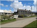
Llanvirn Farm
Entrance to Llanvirn Farm.
Image: © Alan Hughes
Taken: 24 May 2016
0.16 miles
2
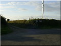
Track to Llanvyrn Farm
The start of the track to Llanvryn Farm, viewed from the minor road junction near Berea.
Image: © Martyn Harries
Taken: 28 Aug 2011
0.16 miles
3
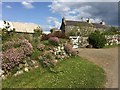
Llanvirn
Cottages by the lane to the coast at Abereiddy.
Image: © Jonathan Billinger
Taken: 27 Apr 2010
0.17 miles
4
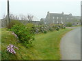
Llanvirn farmhouse
Llanvirn farmhouse does not appear to be part of a working farm any longer, and despite its obvious antiquity has moved to the 21st century with its extensive solar power panels.
The significance of this location to geologists makes it worth a detour, since it is the locality whose name is given to one of the epochs of the Ordovician period. The name was first applied by Henry Hicks, a surgeon from nearby St David's who studied the ancient rocks of the district. In 1881, he named the rocks outcropping at Abereiddi Bay the "Llanvirn Group" and thus coined terminology that is still used by stratigraphers around the world.
Image: © Jonathan Wilkins
Taken: 31 Mar 2016
0.17 miles
5
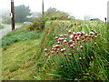
Thrift on a bank
Armeria maritima in a typical habitat near Caerhys.
Image: © Jonathan Billinger
Taken: 27 Apr 2010
0.21 miles
6
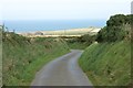
Lane near Croes Llanfyrn
Looking north towards Abereiddi. The slate quarries and Carn Lwyd on the coast north of Abereiddi are visible on the horizon.
Image: © Simon Mortimer
Taken: 23 Aug 2017
0.22 miles
7
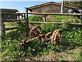
Farm Machinery - Caerhys
Rusty farm machinery at Caerhys.
Image: © Alan Hughes
Taken: 24 May 2016
0.25 miles