IMAGES TAKEN NEAR TO
Pen Y Cwm, HAVERFORDWEST, SA62 6BB
Introduction
This page details the photographs taken nearby to SA62 6BB by members of the Geograph project.
The Geograph project started in 2005 with the aim of publishing, organising and preserving representative images for every square kilometre of Great Britain, Ireland and the Isle of Man.

There are currently over 7.5m images from over14,400 individuals and you can help contribute to the project by visiting https://www.geograph.org.uk
Image Map (5 Images)


Getting Data...Please wait
Leaflet Map data © OpenStreetMap
Images are licensed for reuse under creativecommons.org/licenses/by-sa/2.0
Notes
- Clicking on the map will re-center to the selected point.
- The higher the marker number, the further away the image location is from the centre of the postcode.
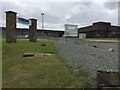
Image Listing (5 Images Found)
Images are licensed for reuse under creativecommons.org/licenses/by-sa/2.0
Image
Details
Distance
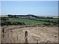
1
Brawdy Business Park
Entrance to Brawdy Business Park.
Image: © Alan Hughes
Taken: 25 May 2016
0.13 miles
2
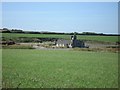
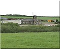
Ruined buildings on the edge of RAF Brawdy
Image: © Simon Mortimer
Taken: 1 Aug 2007
0.20 miles
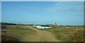
4
Ruined Building
Ruined building, perhaps an RAF Brawdy outbuilding?
Image: © Alan Hughes
Taken: 25 May 2016
0.21 miles