IMAGES TAKEN NEAR TO
Pen Y Cwm, HAVERFORDWEST, SA62 6AX
Introduction
This page details the photographs taken nearby to SA62 6AX by members of the Geograph project.
The Geograph project started in 2005 with the aim of publishing, organising and preserving representative images for every square kilometre of Great Britain, Ireland and the Isle of Man.

There are currently over 7.5m images from over14,400 individuals and you can help contribute to the project by visiting https://www.geograph.org.uk
Image Map
Images are licensed for reuse under creativecommons.org/licenses/by-sa/2.0
Notes
- Clicking on the map will re-center to the selected point.
- The higher the marker number, the further away the image location is from the centre of the postcode.
Image Listing (14 Images Found)
Images are licensed for reuse under creativecommons.org/licenses/by-sa/2.0
Image
Details
Distance
1
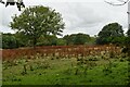
Pasture with docks near Llethr
The field was once part of the grounds of the manor house at Llethr, the roof of which can be seen in the background..
Image: © Simon Mortimer
Taken: 2 Aug 2021
0.13 miles
2
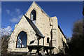
Converted Chapel
Converted Chapel at Pen-y-Cwm.
Image: © Alan Hughes
Taken: 23 Feb 2016
0.14 miles
4
The hamlet of Penycwm
Meaning, 'Head of the Valley'.
Image: © Deborah Tilley
Taken: 26 Jan 2009
0.15 miles
5
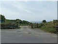
Gated-off track
A track in Penycwm leading down to the coast, accessible for walkers but gated off for motor vehicles.
Image: © Pebble
Taken: 28 May 2023
0.15 miles
6
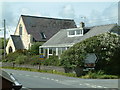
Penycwm, Pembrokeshire
The chapel has been converted into a residential property.
Image: © Robin Lucas
Taken: 23 Jun 2007
0.16 miles
7
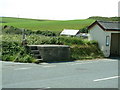
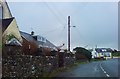
Milk Stand, Penycwm, Pembrokeshire
Farmers used milk stands such as this to place their churns on ready for collection by a dairy. This one is beside the A487 road at Penycwm.
Image: © Robin Lucas
Taken: 23 Jun 2007
0.17 miles
8
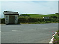
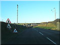
Bus shelter, Penycwm, Pembrokeshire
The bus shelter is alongside the A487 St David's to Haverfordwest road.
Image: © Robin Lucas
Taken: 23 Jun 2007
0.18 miles
9
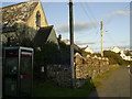
Phone box, Penycwm
The phone box is close to the former chapel, alongside the A487 St David's to Haverfordwest road in Penycwm.
Image: © Martyn Harries
Taken: 28 Aug 2011
0.18 miles
10
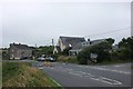
Houses at Penycwm
Looking north across the A487 between Haverfordwest and St. David's. The building in the centre is the former congregational chapel, now holiday accommodation.
Image: © Simon Mortimer
Taken: 29 Jul 2016
0.18 miles