IMAGES TAKEN NEAR TO
Roch, HAVERFORDWEST, SA62 6AP
Introduction
This page details the photographs taken nearby to SA62 6AP by members of the Geograph project.
The Geograph project started in 2005 with the aim of publishing, organising and preserving representative images for every square kilometre of Great Britain, Ireland and the Isle of Man.

There are currently over 7.5m images from over14,400 individuals and you can help contribute to the project by visiting https://www.geograph.org.uk
Image Map (Loading...)


Getting Data...Please wait
Leaflet Map data © OpenStreetMap
Images are licensed for reuse under creativecommons.org/licenses/by-sa/2.0
Notes
- Clicking on the map will re-center to the selected point.
- The higher the marker number, the further away the image location is from the centre of the postcode.
Image Listing (5 Images Found)
Images are licensed for reuse under creativecommons.org/licenses/by-sa/2.0
Image
Details
Distance
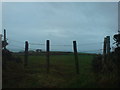
1
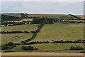
View of Pontpren Farm
Looking south across the valley of Brandy Brook.
Image: © Simon Mortimer
Taken: 2 Aug 2021
0.01 miles
2
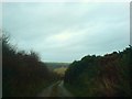
The lane to Pont Pren
With views across Brandy Brook valley to the hill in Brawdy parish.
Image: © Deborah Tilley
Taken: 19 Dec 2008
0.10 miles
3
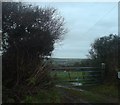
On the track to Gouts
It is hard to believe but this area was once a big supplier of coal and was littered with mines.
Image: © Deborah Tilley
Taken: 19 Dec 2008
0.17 miles
5
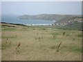
Across the fields to Southwood and St Bride's Bay beyond
Image: © Deborah Tilley
Taken: 19 Dec 2008
0.21 miles