IMAGES TAKEN NEAR TO
Wesley Place, HAVERFORDWEST, SA62 5XR
Introduction
This page details the photographs taken nearby to Wesley Place, SA62 5XR by members of the Geograph project.
The Geograph project started in 2005 with the aim of publishing, organising and preserving representative images for every square kilometre of Great Britain, Ireland and the Isle of Man.

There are currently over 7.5m images from over14,400 individuals and you can help contribute to the project by visiting https://www.geograph.org.uk
Image Map (Loading...)


Getting Data...Please wait
Leaflet Map data © OpenStreetMap
Images are licensed for reuse under creativecommons.org/licenses/by-sa/2.0
Notes
- Clicking on the map will re-center to the selected point.
- The higher the marker number, the further away the image location is from the centre of the postcode.
Image Listing (10 Images Found)
Images are licensed for reuse under creativecommons.org/licenses/by-sa/2.0
Image
Details
Distance
1
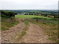
View southwest from Cnwcymorfol
Across the field is the Wesley Place/Rectory Road estate on the edge of the Trecwn valley; right of that can be seen the minor road leading towards the A40. The distant horizon is the coast.
Image: © Natasha Ceridwen de Chroustchoff
Taken: 18 Jun 2010
0.04 miles
2
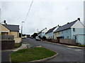
Wesley Place, Trecwn
I am standing in this grid square but everything, apart from the immediate foreground and the house on the right, is in Image
Wesley Place was a small mid-C20 council estate built to house workers at the nearby RNAD munitions depot. It is named after the sole eminent personage associated with the village: Charles Wesley who preached near here in 1777.
Image: © Natasha Ceridwen de Chroustchoff
Taken: 18 Jun 2010
0.05 miles
3
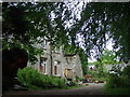
Old Llanstinan rectory
A very old house which has long been suffering from neglect but it looks as if repairs are afoot now.
Image: © Natasha Ceridwen de Chroustchoff
Taken: 18 Jun 2010
0.06 miles
4

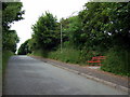
Entrance to Llanstinan old rectory
Former rectory, which, although now in the community designated Trecwn, used to be within the parish of Llanstinan, of which the church lies a mile or so away (as the crow flies) to the northwest, see Image There may have been a direct route between the two once.
Image: © Natasha Ceridwen de Chroustchoff
Taken: 18 Jun 2010
0.07 miles
5
Red bench by the road
There is no view to admire on this quiet, shady hill between the upper and lower portions of Trecwn but someone seems to love this roadside bench: it has been daubed with gold stars and friendly peace slogans.
Image: © Natasha Ceridwen de Chroustchoff
Taken: 18 Jun 2010
0.10 miles
6
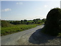
Road junction near Trecwn
The view of the road junction from the entrance to Escalwen.
Image: © Martyn Harries
Taken: 9 Jul 2011
0.16 miles
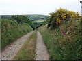
7
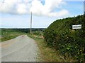
Track to Escalwen
Leading to Escalwen Farm north of Trecwn.
Image: © Stephen McKay
Taken: 23 Jul 2006
0.20 miles
8
Track to Penbicas
Track leading to Penbicas Farm.
Image: © Alan Hughes
Taken: 27 Jun 2018
0.21 miles
9
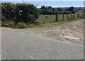
Track junction
Junction of minor road with track leading to Penbicas Farm.
Image: © Alan Hughes
Taken: 27 Jun 2018
0.23 miles
10
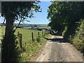
Old lane to Trecwn
A route for walkers and farm vehicles now but once it would have been a way to get to the church of St Mary's, Llanfair Nant-y-Gof, which is the grey building just visible across the valley, see Image]
Image: © Natasha Ceridwen de Chroustchoff
Taken: 18 Jun 2010
0.23 miles