IMAGES TAKEN NEAR TO
Brynawelon Court, HAVERFORDWEST, SA62 5UF
Introduction
This page details the photographs taken nearby to Brynawelon Court, SA62 5UF by members of the Geograph project.
The Geograph project started in 2005 with the aim of publishing, organising and preserving representative images for every square kilometre of Great Britain, Ireland and the Isle of Man.

There are currently over 7.5m images from over14,400 individuals and you can help contribute to the project by visiting https://www.geograph.org.uk
Image Map (Loading...)


Getting Data...Please wait
Leaflet Map data © OpenStreetMap
Images are licensed for reuse under creativecommons.org/licenses/by-sa/2.0
Notes
- Clicking on the map will re-center to the selected point.
- The higher the marker number, the further away the image location is from the centre of the postcode.
Image Listing (7 Images Found)
Images are licensed for reuse under creativecommons.org/licenses/by-sa/2.0
Image
Details
Distance
1
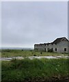
Abandoned building site?
According to Image taken 5 years ago this was to be a development of 18 houses
Image: © Eirian Evans
Taken: 1 May 2022
0.01 miles
2
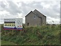
Hotel or residential development?
Marked on the OS map as a hotel, the site is currently being developed for residential properties.
Image: © Alan Hughes
Taken: 10 Oct 2017
0.03 miles
3
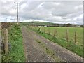
Track leading to Good Hope
The track leads to Good Hope. Out of sight to the right ( - where the grass is always greener?) is Better Hope!
Image: © Alan Hughes
Taken: 10 Oct 2017
0.05 miles
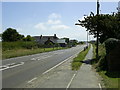
4

Road junction near Letterston
The minor road from Sealyham makes a 'T' junction with the A40 near Letterston.
Image: © Martyn Harries
Taken: 17 Aug 2010
0.14 miles
5
The Harp Inn, Letterston
A popular roadside pub and restaurant on the A40 Fishguard to Haverfordwest road and is located on the outskirts of Letterston.
Image: © Martyn Harries
Taken: 19 Jun 2010
0.23 miles

7
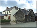
Harp Inn, Letterston
The Harp Inn, Letterston.
Image: © Alan Hughes
Taken: 16 May 2016
0.24 miles