IMAGES TAKEN NEAR TO
Haverfordwest Road, HAVERFORDWEST, SA62 5UA
Introduction
This page details the photographs taken nearby to Haverfordwest Road, SA62 5UA by members of the Geograph project.
The Geograph project started in 2005 with the aim of publishing, organising and preserving representative images for every square kilometre of Great Britain, Ireland and the Isle of Man.

There are currently over 7.5m images from over14,400 individuals and you can help contribute to the project by visiting https://www.geograph.org.uk
Image Map
Images are licensed for reuse under creativecommons.org/licenses/by-sa/2.0
Notes
- Clicking on the map will re-center to the selected point.
- The higher the marker number, the further away the image location is from the centre of the postcode.
Image Listing (33 Images Found)
Images are licensed for reuse under creativecommons.org/licenses/by-sa/2.0
Image
Details
Distance
3
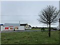
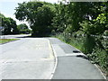
Total Petrol Station, Letterston
The shop and petrol station is located beside the A40 and is the only petrol station between Fishguard and the outskirts of Haverfordwest.
Image: © Martyn Harries
Taken: 19 Jun 2010
0.04 miles

5
Harp Inn, Letterston
The Harp Inn, Letterston.
Image: © Alan Hughes
Taken: 16 May 2016
0.10 miles
6
The Harp Inn, Letterston
A popular roadside pub and restaurant on the A40 Fishguard to Haverfordwest road and is located on the outskirts of Letterston.
Image: © Martyn Harries
Taken: 19 Jun 2010
0.11 miles
7
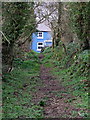
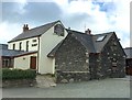
Path to a blue house
One of the many old pathways in this area led me to a row of quiet cottages at Summerhill south of Treletert/Letterston.
Image: © Natasha Ceridwen de Chroustchoff
Taken: 26 Mar 2009
0.13 miles
8
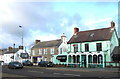
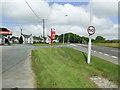
Letterston Square road junction
The ancient settlement of Treletert/Letterston (named after the Lettard family who once owned it) is strung out along a east-west axis but has the misfortune to be bisected here in the centre by the A40 running north-south: being a trunk road the speed limit is no lower than 40mph and traffic is a major hazard. This well-regarded fish and chip restaurant benefits from the passing trade however.
Image: © Natasha Ceridwen de Chroustchoff
Taken: 8 Dec 2006
0.18 miles
9
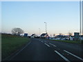
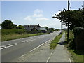
Bus Stop by the A40, Letterston
The bus stop is located by the A40 near the village's public conveniences.
Image: © Martyn Harries
Taken: 19 Jun 2010
0.18 miles
10

TrawsCymru bus in Letterston
At the bus stop set back from the west side of the A40 Haverfordwest Road,
the TrawsCymru bus is on Route T5 from Haverfordwest to Fishguard.
Image: © Jaggery
Taken: 20 Feb 2019
0.20 miles