IMAGES TAKEN NEAR TO
Letterston, HAVERFORDWEST, SA62 5TP
Introduction
This page details the photographs taken nearby to SA62 5TP by members of the Geograph project.
The Geograph project started in 2005 with the aim of publishing, organising and preserving representative images for every square kilometre of Great Britain, Ireland and the Isle of Man.

There are currently over 7.5m images from over14,400 individuals and you can help contribute to the project by visiting https://www.geograph.org.uk
Image Map (Loading...)


Getting Data...Please wait
Leaflet Map data © OpenStreetMap
Images are licensed for reuse under creativecommons.org/licenses/by-sa/2.0
Notes
- Clicking on the map will re-center to the selected point.
- The higher the marker number, the further away the image location is from the centre of the postcode.
Image Listing (2 Images Found)
Images are licensed for reuse under creativecommons.org/licenses/by-sa/2.0
Image
Details
Distance
1
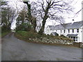
Garn Deifog
An isolated group of houses up a dead-end lane south-east of Trecwn.
Image: © Jonathan Billinger
Taken: 16 Nov 2007
0.03 miles
2

Bridleway beyond Garn Deifog
This was track was metalled fairly recently, but its use as a road stopped by a vehicle-proof barrier about 300 yards away from here. A good example of Jack-in-the-Green taking back his territory!
Image: © Jonathan Billinger
Taken: 16 Nov 2007
0.19 miles