IMAGES TAKEN NEAR TO
Letterston, HAVERFORDWEST, SA62 5SY
Introduction
This page details the photographs taken nearby to SA62 5SY by members of the Geograph project.
The Geograph project started in 2005 with the aim of publishing, organising and preserving representative images for every square kilometre of Great Britain, Ireland and the Isle of Man.

There are currently over 7.5m images from over14,400 individuals and you can help contribute to the project by visiting https://www.geograph.org.uk
Image Map (Loading...)


Getting Data...Please wait
Leaflet Map data © OpenStreetMap
Images are licensed for reuse under creativecommons.org/licenses/by-sa/2.0
Notes
- Clicking on the map will re-center to the selected point.
- The higher the marker number, the further away the image location is from the centre of the postcode.
Image Listing (17 Images Found)
Images are licensed for reuse under creativecommons.org/licenses/by-sa/2.0
Image
Details
Distance
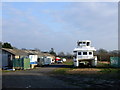
1
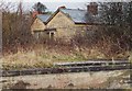
Letterston station, North Pembrokeshire
Letterston was the most westerly station on a branch that served North Pembrokeshire by forming a loop off the GWR main line to Fishguard Harbour. The last passenger train ran in 1937 and most of the line closed to goods traffic in 1949. The old loading bay survives alongside the wooden station building still in use as a residence.
Image: © Ralph Rawlinson
Taken: 31 Mar 2002
0.04 miles
2
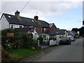
Station Terrace, Treletert/Letterston
This row of cottages, which is beyond the village proper, is named for its proximity to the former station on the dismantled North Pembrokeshire railway.
Image: © Natasha Ceridwen de Chroustchoff
Taken: 12 Sep 2008
0.04 miles
3
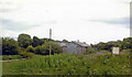
Site of Letterston station, 2004
View SE, towards Clynderwen: ex-GWR Clynderwen - Rosebush - Fishguard branch. Until the shorter line from Clarbeston Road to Fishguard was opened in 8/1906 as the main line, this little-known branch was the access to Fishguard. The branch through Rosebush was closed 25/10/37 (goods 16/5/49), but the short stretch west from Letterston survived (for goods) until 1/3/65.
Image: © Ben Brooksbank
Taken: 23 Jun 2004
0.04 miles
4
Letterston railway station (site), Pembrokeshire
Opened in 1895 by the North Pembrokeshire and Fishguard Railway, later part of the Great Western Railway, on its line from Clunderwen to Fishguard & Goodwick, this station closed to passengers in 1937 and completely in 1965. View south east towards Beulah Halt and Clunderwen. No trace apparently remains. The site has become more overgrown in the seven years since Image was taken. For more details, see http://www.disused-stations.org.uk/l/letterston/index.shtml .
Image: © Nigel Thompson
Taken: 6 Jun 2017
0.07 miles
5
Boatyard in Letterston
An odd sight at the edge of the village. The ?houseboat seems to be under construction here.
Image: © Natasha Ceridwen de Chroustchoff
Taken: 2 Jan 2009
0.07 miles
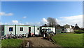
6
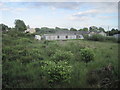
Site of Letterston railway station
This is the site of the small station at Letterston, opened in 1895, originally as part of The North Pembrokeshire and Fishguard Railway, between Fishguard & Goodwick and Clynderwen, before the line was taken over by the Great Western Railway. Passenger services were withdrawn in 1937, but goods traffic was retained until 1965. The main station buildings and signal box were situated on the Up platform, near the dark green trees in the distance, on the left side of the railway lines. The goods yard and cattle pens on the Down platform were situated on the right side of the railway lines, where the buildings in the distance are sited. Hardly a trace of the old station remains, although the course of the former railway line can be followed from this spot.
Image: © Martyn Harries
Taken: 15 Apr 2010
0.07 miles
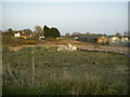
7
The Remakery, Letterston
A series of portakabins in the disused railway yard has become home to a recycling project that undertakes to make good or re-use (if necessary by cannibalising) broken or unwanted items: furniture, bicycles, tools, appliances, electronic devices, and so on, either for a charge or to sell on or to give to charities. Initiatives like this are springing up in response to the wastage and expense promoted by our consumer society and the polluting effect of the throwaway, single use goods.
Image: © Natasha Ceridwen de Chroustchoff
Taken: 15 Feb 2018
0.10 miles
8
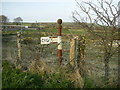
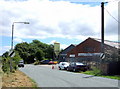
Old finger post, Letterston
All directional signs are broken on this old finger post, positioned opposite the Farmers' Co-op (Letterston Branch).
Image: © Martyn Harries
Taken: 15 Apr 2010
0.13 miles
9
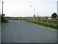
Minor road junction at Letterston
View of the road junction near the Farmers' Co-op, turn left for Station Road to join the A40, and turn right and right again, for Little Newcastle and Puncheston.
Image: © Martyn Harries
Taken: 15 Apr 2010
0.15 miles
10
Farmers' Co-op
Serving the agricultural community locally: animal feed, medication, equipment, clothing and everything else a farmer could need can be picked up here.
Image: © Natasha Ceridwen de Chroustchoff
Taken: 11 Jul 2006
0.15 miles