IMAGES TAKEN NEAR TO
Jubilee Close, HAVERFORDWEST, SA62 5SW
Introduction
This page details the photographs taken nearby to Jubilee Close, SA62 5SW by members of the Geograph project.
The Geograph project started in 2005 with the aim of publishing, organising and preserving representative images for every square kilometre of Great Britain, Ireland and the Isle of Man.

There are currently over 7.5m images from over14,400 individuals and you can help contribute to the project by visiting https://www.geograph.org.uk
Image Map (Loading...)


Getting Data...Please wait
Leaflet Map data © OpenStreetMap
Images are licensed for reuse under creativecommons.org/licenses/by-sa/2.0
Notes
- Clicking on the map will re-center to the selected point.
- The higher the marker number, the further away the image location is from the centre of the postcode.
Image Listing (41 Images Found)
Images are licensed for reuse under creativecommons.org/licenses/by-sa/2.0
Image
Details
Distance
1

Path through a Letterston cemetery
From the north side of Station Road in Letterston Pembrokeshire.
Image: © Jaggery
Taken: 20 Feb 2019
0.05 miles
2

Blaenoriaeth/Priority sign, Station Road, Letterston
Welsh/English sign on the approach to Station Road traffic calming.
Image: © Jaggery
Taken: 20 Feb 2019
0.06 miles
3

Deciduous trees at the northern edge of a Letterston cemetery
On the north side of Station Road viewed in February 2019.
From a distance I thought the monument could be Letterston War Memorial. It isn't.
Image: © Jaggery
Taken: 20 Feb 2019
0.06 miles
4
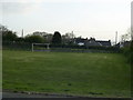
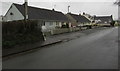
Tennis courts at Letterston
View from the car park by Letterston Memorial Hall, two tennis courts on Station Road.
Image: © Martyn Harries
Taken: 10 May 2010
0.09 miles
5
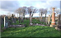
Burial ground, Station Road,Treletert/Letterston
This is the older section of a very neatly maintained and well-ordered cemetery; the more recent graves are to the right. A plaque at the entrance explains that the gate and path were rebuilt in 1953 with the help of a benefactor (Mr Thomas of London) in memory of his parents. He also provided the bus shelter on the main road.
Image: © Natasha Ceridwen de Chroustchoff
Taken: 8 Dec 2006
0.09 miles
6
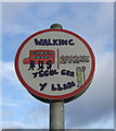
Walking bus stop, Station Road
A pick-up point for the 'walking bus' to the village school, 'ger y llan' (near the church). The scheme, whereby groups of children walk to school under the supervision of volunteer helpers, was introduced nationally in order to limit traffic congestion, reduce fuel consumption and promote healthy exercise. Since getting to school from here involves crossing the fast and busy A40 road, this is a valuable community initiative and the sign has been designed by the children themselves.
Image: © Natasha Ceridwen de Chroustchoff
Taken: 8 Dec 2006
0.09 miles
7
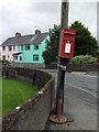
Letterston letterbox, uprooted
Presumably it's only temporarily stationed here, in Station Road, while it awaits replanting.
Image: © Natasha Ceridwen de Chroustchoff
Taken: 12 Sep 2008
0.10 miles
8
Station Road bungalows, Letterston
On the approach to the A40 junction.
Image: © Jaggery
Taken: 20 Feb 2019
0.11 miles
9
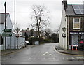
Western end of Station Road, Letterston
Looking east along Station Road across the A40. The name is a reminder of the former railway station in the village. The Disused Stations website records that Letterston was the largest station on the North Pembrokeshire & Fishguard Railway. When it opened on April 11th 1895 it was the terminus of the line from Clynderwen. Letterston Station closed to passengers in October 1937 and closed completely on March 1st 1965.
A40 signs on the left show Fishguard (Abergwaun in Welsh) 5 miles to the left.
Haverfordwest (Hwlffordd in Welsh) 10 miles to the right.
Preseli Lettings office https://www.geograph.org.uk/photo/6065572 is on the right.
Image: © Jaggery
Taken: 20 Feb 2019
0.11 miles
10

Preseli Lettings office, 1 Haverfordwest Road, Letterston
Independent letting agents & property management company on the corner of Station Road.
Image: © Jaggery
Taken: 20 Feb 2019
0.13 miles