IMAGES TAKEN NEAR TO
Min Y Llan, HAVERFORDWEST, SA62 5SP
Introduction
This page details the photographs taken nearby to Min Y Llan, SA62 5SP by members of the Geograph project.
The Geograph project started in 2005 with the aim of publishing, organising and preserving representative images for every square kilometre of Great Britain, Ireland and the Isle of Man.

There are currently over 7.5m images from over14,400 individuals and you can help contribute to the project by visiting https://www.geograph.org.uk
Image Map (Loading...)


Getting Data...Please wait
Leaflet Map data © OpenStreetMap
Images are licensed for reuse under creativecommons.org/licenses/by-sa/2.0
Notes
- Clicking on the map will re-center to the selected point.
- The higher the marker number, the further away the image location is from the centre of the postcode.
Image Listing (24 Images Found)
Images are licensed for reuse under creativecommons.org/licenses/by-sa/2.0
Image
Details
Distance
1
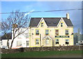
The Jubilee Hotel, Treletert/Letterston
A popular local pub with accommodation and a view across the recreation ground.
Image: © Natasha Ceridwen de Chroustchoff
Taken: 8 Dec 2006
0.11 miles
2
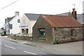
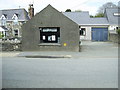
Electrical shop, Letterston
The electrical shop is on the site of a former smithy which served the village for many years up to the 1970s. The current shop, next door to The Jubilee Pub, replaced the smaller shop Image
Image: © Martyn Harries
Taken: 10 May 2010
0.11 miles
3
Road Out Of Letterston
Town or village?
Image: © Deborah Tilley
Taken: 30 Oct 2015
0.11 miles
4
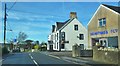
Centre of the village, Letterston
Looking west along St David's Road, past the showroom of an electrical appliance shop, towards The Jubilee pub.
Image: © Simon Mortimer
Taken: 29 Aug 2013
0.12 miles
5
Old shop front, Letterston
The old shop front of Mathias Refrigeration before moving to the newer electrical shop , next to The Jubilee.
Image: © Martyn Harries
Taken: 10 May 2010
0.14 miles
6
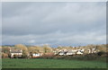
Treletert/Letterston from the west
Approaching the lower part of this straggling village via a footpath across fields. Much of the housing to be seen here is recent infill development.
Image: © Natasha Ceridwen de Chroustchoff
Taken: 8 Dec 2006
0.14 miles
7
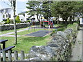
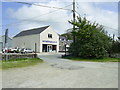
Play area for infants, Letterston
A small enclosed play area for infants opposite St.Giles church and churchyard.
Image: © Martyn Harries
Taken: 10 May 2010
0.15 miles
8
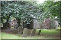
Churchyard, St Giles Church Letterston
Image: © Simon Mortimer
Taken: 29 Aug 2013
0.16 miles
9
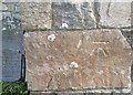
Ordnance Survey Cut Mark
This OS cut mark can be found on the west face of St Giles Church. It marks a point 111.837m above mean sea level.
Image: © Adrian Dust
Taken: 4 Mar 2020
0.16 miles
10
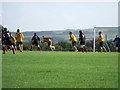
Letterston versus Goodwick United II, Letterston
Letterston are in gold and Goodwick in the black and red shirts.
Image: © nick macneill
Taken: 8 Sep 2010
0.16 miles