IMAGES TAKEN NEAR TO
Puncheston, HAVERFORDWEST, SA62 5RN
Introduction
This page details the photographs taken nearby to SA62 5RN by members of the Geograph project.
The Geograph project started in 2005 with the aim of publishing, organising and preserving representative images for every square kilometre of Great Britain, Ireland and the Isle of Man.

There are currently over 7.5m images from over14,400 individuals and you can help contribute to the project by visiting https://www.geograph.org.uk
Image Map (Loading...)


Getting Data...Please wait
Leaflet Map data © OpenStreetMap
Images are licensed for reuse under creativecommons.org/licenses/by-sa/2.0
Notes
- Clicking on the map will re-center to the selected point.
- The higher the marker number, the further away the image location is from the centre of the postcode.
Image Listing (24 Images Found)
Images are licensed for reuse under creativecommons.org/licenses/by-sa/2.0
Image
Details
Distance
1
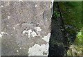
Ordnance Survey Cut Mark
This OS cut mark can be found on the SE face of St Mary's Church. It marks a point 156.954m above mean sea level.
Image: © Adrian Dust
Taken: 27 Feb 2017
0.02 miles
2
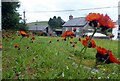
Fox-and-cubs in Casmael churchyard
Pilosella aurantiaca, very often to be found growing in churchyards, cemeteries and other rough stony places with good drainage.
The name Fox-and-cubs refers to the way the open flowers and the buds are clustered together on the same stalk but it has a variety of other common names too.
Image: © Natasha Ceridwen de Chroustchoff
Taken: 9 Jul 2021
0.02 miles
3
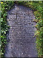
Gravestone paving
Old gravestones have been used to create stepping stones across the churchyard.
Image: © Natasha Ceridwen de Chroustchoff
Taken: 4 Sep 2008
0.02 miles
4
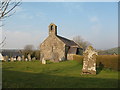
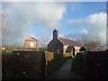
St Mary's Church Puncheston.
The village church stands on a small hillock and is close to the slight remains of a castle.
Image: © Gordon Hatton
Taken: 2 Apr 2007
0.02 miles
6
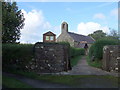
Church entrance, Casmael/Puncheston
There was a church recorded here in the C14 but this is a Victorian reconstruction. A mediaeval font remains inside.
It has connections with the Gambold family: William Gambold (1672-1728) who was rector here published a Grammar of the Welsh Language and also worked on a Welsh/English dictionary. Of his 5 sons born in Puncheston the eldest John (1711-1771) became an early Moravian bishop, and several others were notable too. See http://yba.llgc.org.uk/en/s-GAMB-OLD-1650.html
Image: © Natasha Ceridwen de Chroustchoff
Taken: 4 Sep 2008
0.04 miles
7

Churchyard, Casmael/Puncheston
A pretty farmhouse stands behind the churchyard where old gravestones have been employed to form a path.
Image: © Natasha Ceridwen de Chroustchoff
Taken: 4 Sep 2008
0.04 miles
8

View from the church
Looking ENE from beside the church towards the slopes of Mynydd Castlebythe. Among the trees behind the stone house stands the remnant of the Norman castle motte that gives Casmael its Welsh name. The English name is thought to derive from the Norman placename Pontchardon, possibly belonging to one of the knights who colonised this area.
Image: © Natasha Ceridwen de Chroustchoff
Taken: 4 Sep 2008
0.05 miles
9
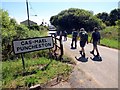
Cas-Mael / Puncheston
Cerddwyr yn cyrraedd pentre Cas-Mael.
Walkers arriving at the village of Puncheston.
Image: © Alan Richards
Taken: 22 Jun 2014
0.07 miles
10
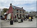
The Drovers Arms
Public house in Puncheston.
Image: © Alan Hughes
Taken: 21 Apr 2021
0.09 miles