IMAGES TAKEN NEAR TO
Hayscastle, HAVERFORDWEST, SA62 5PU
Introduction
This page details the photographs taken nearby to SA62 5PU by members of the Geograph project.
The Geograph project started in 2005 with the aim of publishing, organising and preserving representative images for every square kilometre of Great Britain, Ireland and the Isle of Man.

There are currently over 7.5m images from over14,400 individuals and you can help contribute to the project by visiting https://www.geograph.org.uk
Image Map (Loading...)


Getting Data...Please wait
Leaflet Map data © OpenStreetMap
Images are licensed for reuse under creativecommons.org/licenses/by-sa/2.0
Notes
- Clicking on the map will re-center to the selected point.
- The higher the marker number, the further away the image location is from the centre of the postcode.
Image Listing (13 Images Found)
Images are licensed for reuse under creativecommons.org/licenses/by-sa/2.0
Image
Details
Distance
1
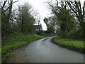
Minor road junction, Hayscastle
The road on the left leads to Pont-yr-Hafod.
Image: © Martyn Harries
Taken: 20 Nov 2010
0.03 miles
2
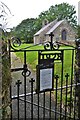
St David's Church, Hayscastle
A Celtic (as opposed to Norman) style church
Image: © Deborah Tilley
Taken: 6 Aug 2015
0.04 miles
3
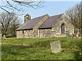
St Mary?s Church, Hayscastle
The church sits just south of the main junction of lanes close to Upper Hayscastle.
Image: © Alan Hughes
Taken: 21 Apr 2021
0.04 miles
4
North Aspect Of St David's Church, Hayscastle
Looking south
Image: © Deborah Tilley
Taken: 6 Aug 2015
0.04 miles
5
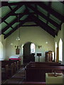
Cas-lai/Hayscastle church interior
Once a simple single-cell church, a wall was inserted at some point to create a nave and chancel, the arch being only 5 feet wide. The font is C13 but the pulpit and stained glass were added in 1928.
Image: © Natasha Ceridwen de Chroustchoff
Taken: 12 Apr 2009
0.06 miles
6
Churchyard, Cas-lai/Hayscastle
The churchyard, which is well-tree'd, is of a roughly circular shape, which, along with the low, Celtic-style church, suggests that this was a pagan holy place Christianized long before the Normans colonized this region of the Englishry.
Image: © Natasha Ceridwen de Chroustchoff
Taken: 12 Apr 2009
0.06 miles
7
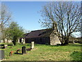
Cas-lai/Hayscastle church
The tiny church squats low and long, Celtic-style, in this Norman village. Evidently Mediaeval in origin but restored in the 1860s.
The Pevsner guide states it is dedicated to St David (in whose prebendary it fell) but everywhere else gives it as St Mary the Virgin's.
Image: © Natasha Ceridwen de Chroustchoff
Taken: 12 Apr 2009
0.07 miles

9
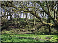
Motte at Cas-lai/Hayscastle
A tree-covered mound is all that remains of Haye's Castle, one of several such earth fortifications in the area, erected by the Normans advancing from the coast and attempting to take control of the hinterland. There is no sign of a bailey but the motte still possesses a boggy moat, seen here in the foreground.
Image: © Natasha Ceridwen de Chroustchoff
Taken: 12 Apr 2009
0.07 miles
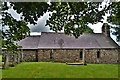
10
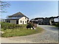
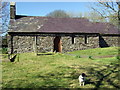
Upper Hayscastle
Upper Hayscastle Farm.
Image: © Alan Hughes
Taken: 21 Apr 2021
0.09 miles