IMAGES TAKEN NEAR TO
Welsh Hook, Wolfscastle, HAVERFORDWEST, SA62 5NR
Introduction
This page details the photographs taken nearby to SA62 5NR by members of the Geograph project.
The Geograph project started in 2005 with the aim of publishing, organising and preserving representative images for every square kilometre of Great Britain, Ireland and the Isle of Man.

There are currently over 7.5m images from over14,400 individuals and you can help contribute to the project by visiting https://www.geograph.org.uk
Image Map (Loading...)


Getting Data...Please wait
Leaflet Map data © OpenStreetMap
Images are licensed for reuse under creativecommons.org/licenses/by-sa/2.0
Notes
- Clicking on the map will re-center to the selected point.
- The higher the marker number, the further away the image location is from the centre of the postcode.
Image Listing (19 Images Found)
Images are licensed for reuse under creativecommons.org/licenses/by-sa/2.0
Image
Details
Distance
1
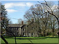
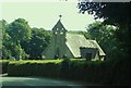
Old rectory , Welsh Hook
Just up the road from the church, a sizeable mid-C19 house for an incumbent's large family. Several chimneys, suggesting a fire in every room at one time.
Image: © Natasha Ceridwen de Chroustchoff
Taken: 12 Apr 2009
0.03 miles
2
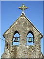
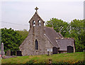
The bells of St Lawrence
The church has a huge bellcote with twin bells. Maybe a strong peal was needed to reach the ears of the scattered congregation in this rural community.
Image: © Natasha Ceridwen de Chroustchoff
Taken: 26 Mar 2009
0.06 miles
5
Chancel: St Lawrence Parish Church
Just before sunset.
Image: © Dylan Moore
Taken: 22 Nov 2013
0.07 miles
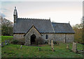
8
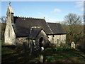
St Lawrence from the northwest
This tiny church stands on an elevated site above the river. The churchyard slopes sharply and has a damp, mossy appearance with graves barely legible.
Image: © Natasha Ceridwen de Chroustchoff
Taken: 26 Mar 2009
0.08 miles
9
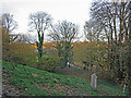
St Lawrence church yard
The northeast corner, with Welsh Hook beyond and the Western Cleddau below.
Image: © Dylan Moore
Taken: 22 Nov 2013
0.08 miles
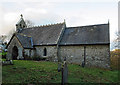
10
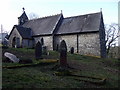
St Lawrence from the southeast
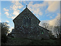
The scattered settlement here on the south bank of the Cleddau Wen used to be called St Lawrence after the church, but has now been subsumed under the name Welsh Hook.
This was evidently an ancient church heavily restored by E. Lingen Barker in 1877. The south wall and porch retain their mediaeval appearance.
Image: © Natasha Ceridwen de Chroustchoff
Taken: 26 Mar 2009
0.09 miles