IMAGES TAKEN NEAR TO
Treffgarne, HAVERFORDWEST, SA62 5LW
Introduction
This page details the photographs taken nearby to SA62 5LW by members of the Geograph project.
The Geograph project started in 2005 with the aim of publishing, organising and preserving representative images for every square kilometre of Great Britain, Ireland and the Isle of Man.

There are currently over 7.5m images from over14,400 individuals and you can help contribute to the project by visiting https://www.geograph.org.uk
Image Map
Images are licensed for reuse under creativecommons.org/licenses/by-sa/2.0
Notes
- Clicking on the map will re-center to the selected point.
- The higher the marker number, the further away the image location is from the centre of the postcode.
Image Listing (2 Images Found)
Images are licensed for reuse under creativecommons.org/licenses/by-sa/2.0
Image
Details
Distance
1
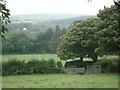
View across the Cleddau valley to Barris Hill
Image: © Simon Mortimer
Taken: 3 Aug 2007
0.16 miles
2

Roadworks and traffic lights, near Treffgarne
These traffic lights were on A40 near Treffgarne Bridge and just ahead of the 'T' junction to Spittal. In the distance is the road improvement scheme by The Kell.
Image: © Martyn Harries
Taken: 17 Aug 2010
0.24 miles