IMAGES TAKEN NEAR TO
Treffgarne, HAVERFORDWEST, SA62 5LN
Introduction
This page details the photographs taken nearby to SA62 5LN by members of the Geograph project.
The Geograph project started in 2005 with the aim of publishing, organising and preserving representative images for every square kilometre of Great Britain, Ireland and the Isle of Man.

There are currently over 7.5m images from over14,400 individuals and you can help contribute to the project by visiting https://www.geograph.org.uk
Image Map
Images are licensed for reuse under creativecommons.org/licenses/by-sa/2.0
Notes
- Clicking on the map will re-center to the selected point.
- The higher the marker number, the further away the image location is from the centre of the postcode.
Image Listing (4 Images Found)
Images are licensed for reuse under creativecommons.org/licenses/by-sa/2.0
Image
Details
Distance
1
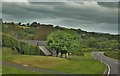
The Old Mill Near Treffgarne Bridge
Just off the A40 and overlooking the Cleddau Wen
Image: © Deborah Tilley
Taken: 25 May 2015
0.02 miles
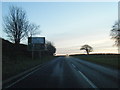
3
Roadworks south of Trefgarne, Pembrokeshire
Image: © nick macneill
Taken: 8 Sep 2010
0.11 miles
4
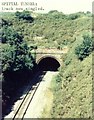
Spittal Tunnel
Southern portal of 242yd Spittal Tunnel, on the former GW, photographed in 1978.
Image: © Bill Blair
Taken: Unknown
0.25 miles