IMAGES TAKEN NEAR TO
Mathry, HAVERFORDWEST, SA62 5JA
Introduction
This page details the photographs taken nearby to SA62 5JA by members of the Geograph project.
The Geograph project started in 2005 with the aim of publishing, organising and preserving representative images for every square kilometre of Great Britain, Ireland and the Isle of Man.

There are currently over 7.5m images from over14,400 individuals and you can help contribute to the project by visiting https://www.geograph.org.uk
Image Map (Loading...)


Getting Data...Please wait
Leaflet Map data © OpenStreetMap
Images are licensed for reuse under creativecommons.org/licenses/by-sa/2.0
Notes
- Clicking on the map will re-center to the selected point.
- The higher the marker number, the further away the image location is from the centre of the postcode.
Image Listing (6 Images Found)
Images are licensed for reuse under creativecommons.org/licenses/by-sa/2.0
Image
Details
Distance
1
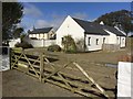
Mabws Uchaf
Claiming to be 'Probably the most energy efficient barn conversion in Wales.' http://www.banbeck.co.uk
Image: © Alan Hughes
Taken: 25 Sep 2017
0.01 miles
2
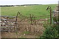
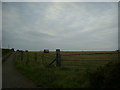
Dilapidated field gate near Pen-lan-Mabws
Looking north from the T-junction near Mabws-uchaf.
Image: © Simon Mortimer
Taken: 23 Aug 2013
0.09 miles
3
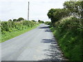
Rural road junction
Rural road junction between Pen-lan-mabws and Mabws-uchaf. Straight on for Letterston; turn right for Hayscastle Cross.
Image: © Martyn Harries
Taken: 25 Jul 2010
0.10 miles
4
Round bales of straw, Llain Farm
Round bales of straw in a field by the track to Llain Farm. The peak of Garn Fawr can just be seen in the distance.
Image: © Martyn Harries
Taken: 12 Sep 2010
0.18 miles
5
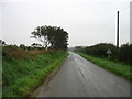
The lane to Pen-lan-mabws
On a depressingly damp morning.
Image: © David Purchase
Taken: 2 Sep 2018
0.21 miles