IMAGES TAKEN NEAR TO
Mathry, HAVERFORDWEST, SA62 5HG
Introduction
This page details the photographs taken nearby to SA62 5HG by members of the Geograph project.
The Geograph project started in 2005 with the aim of publishing, organising and preserving representative images for every square kilometre of Great Britain, Ireland and the Isle of Man.

There are currently over 7.5m images from over14,400 individuals and you can help contribute to the project by visiting https://www.geograph.org.uk
Image Map (Loading...)


Getting Data...Please wait
Leaflet Map data © OpenStreetMap
Images are licensed for reuse under creativecommons.org/licenses/by-sa/2.0
Notes
- Clicking on the map will re-center to the selected point.
- The higher the marker number, the further away the image location is from the centre of the postcode.
Image Listing (3 Images Found)
Images are licensed for reuse under creativecommons.org/licenses/by-sa/2.0
Image
Details
Distance
1
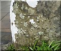
Ordnance Survey Cut Mark
This OS cut mark can be found on the SW angle of the roadside barn at Glandwr Farm. It marks a point 72.920m above mean sea level.
Image: © Adrian Dust
Taken: 4 Mar 2020
0.14 miles
2
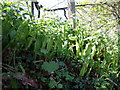
Hart's tongue fern
The strap-like leaves of Asplenium scolopendrium are uncurling on the damp shady roadsides in late spring. It is a lime-loving plant hence in this acidic region often to be found in association with walls and stony banks.
Image: © Natasha Ceridwen de Chroustchoff
Taken: 2 May 2007
0.15 miles
3
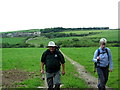
Ger / Near Ffarm Rhoslanog Fawr Farm
Cerddwyr yn dilyn llwybr cyhoeddus ger Ffarm Rhoslanog Fawr. Y ffarm yn y pellter yw Trefelyn.
Walkers following a public footpath near Rhoslanog Fawr Farm. The property in the distance is Trefelyn Farm.
Image: © Alan Richards
Taken: 21 Jun 2009
0.25 miles