IMAGES TAKEN NEAR TO
Mathry, HAVERFORDWEST, SA62 5HB
Introduction
This page details the photographs taken nearby to SA62 5HB by members of the Geograph project.
The Geograph project started in 2005 with the aim of publishing, organising and preserving representative images for every square kilometre of Great Britain, Ireland and the Isle of Man.

There are currently over 7.5m images from over14,400 individuals and you can help contribute to the project by visiting https://www.geograph.org.uk
Image Map (Loading...)


Getting Data...Please wait
Leaflet Map data © OpenStreetMap
Images are licensed for reuse under creativecommons.org/licenses/by-sa/2.0
Notes
- Clicking on the map will re-center to the selected point.
- The higher the marker number, the further away the image location is from the centre of the postcode.
Image Listing (73 Images Found)
Images are licensed for reuse under creativecommons.org/licenses/by-sa/2.0
Image
Details
Distance
1
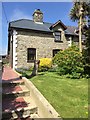
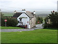
House at Mathry
Well tended garden at house in Mathry.
Image: © Alan Hughes
Taken: 16 May 2016
0.02 miles
2
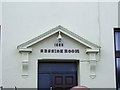
Former Magistrates Court, Mathry
A close-up of the entrance to the former magistrates court built in 1909. Mathry, for many years, from the 19th century till the 1970s, had its own magistrates court. It is now a diving school, but the 'SESSION ROOM' name still remains.
Image: © Martyn Harries
Taken: 2 Apr 2010
0.03 miles
3
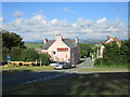
Mathry Hill
Mathry sits on top of a small hill sufficient to give wide views, as here, of the Preseli Hills.
Image: © Jonathan Thacker
Taken: 2 Jul 2015
0.03 miles
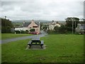
5
Mathry - The Farmers Arms
Village inn at the historic hilltop village of Mathry.
www.visitpembrokeshire.com
Image: © Colin Smith
Taken: 4 Oct 2021
0.04 miles
6
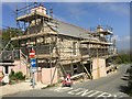
Farmers Arms, Mathry
Work in progress at The Farmers Arms, Mathry.
Image: © Alan Hughes
Taken: 16 May 2016
0.04 miles
7
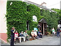
Farmers Arms, Mathri/ Mathry
Cerddwyr yn cael lluniaeth tu fas i Dafarn y Farmers Arms.
Walkers having some refreshments outside the Farmers Arms.
Image: © Alan Richards
Taken: 21 Jun 2009
0.05 miles
8
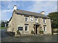
Mathry - The Farmers Arms
Pub in the centre of the historic hilltop Pembrokeshire village of Mathry.
www.visitpembrokeshire.com
Image: © Colin Smith
Taken: 4 Oct 2021
0.05 miles
9
The Farmers Arms
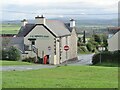
A splendid pub in Mathry, just north of the A487.
The reason for all these 'No Entry' signs eludes me. If you reach the road from behind the pub, it is two-way. This is not exactly a major urban intersection, why not just let people sort it out for themselves.
Image: © David Purchase
Taken: 27 Sep 2019
0.05 miles
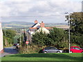
10
One-way traffic system, Mathry
Viewed from the top of Mathry Hill. There is no entry for traffic to travel downhill from the top of the hill past the Farmers Arms pub. The road junction near the pub and below the village green has road signs to remind drivers of the one-way system. Traffic can only travel uphill, one way, from the Farmers Arms pub to the top of the hill. In the distance, between the two no entry signs, is the B4331 road.
Image: © Martyn Harries
Taken: 21 Sep 2009
0.05 miles